04:27 – wake up in Boston
04:47 – depart and drive to route 17 in ME
05:53 – ODO 70.8 +15°C – route 95 rest arear in Kittery, ME. Plenty of gas in the tank. Everything is good and quiet. The new camera is working fine. Forecast promises 11-13°C at night and 24-33°C during the day. I need to connect back to work only on Wednesday, July 6.
07:01 – ODO 135 – Voice memo on iPhone – I was able to record notes on Egor’s latest letter while driving in the car, but no such luck while walking the remote trail. 85 more miles to go.
07:37 – ODO 157.2 +17.5 °C – Hannaford supermarket at Turner, ME
08:56 – ODO 211.9 +14.5°C – arrived at a service road off route 17 in ME. This is less than a mile south of Hight of the Land.
Riding down on a gravel road in not pleasant. It goes too sharply down plus it is crossed with deep cuts (probably anti-erosion in nature) every 200-300 yards. One must stop and carefully navigate through these cuts in the road surface.
09:44 – 09:57 – discovered AT through the thick of the woods. First, I needed to find a way down to the trail, that is passable with a bike in tow. I explored my options and then, after I found an acceptable way down, I transported my bike down as well.
10:09 – I took AT, crossed the brook (Bemis Stream) and reached the road – Bemis Rd.
10:23 Here I hid the bike in the woods and thought that marked the place with a large log on the side of the road.
11:00 Voice memo feature on iPhone requires to be online. Also, voice mail doesn’t show the time when the memo was taken
11:11 – back at the car
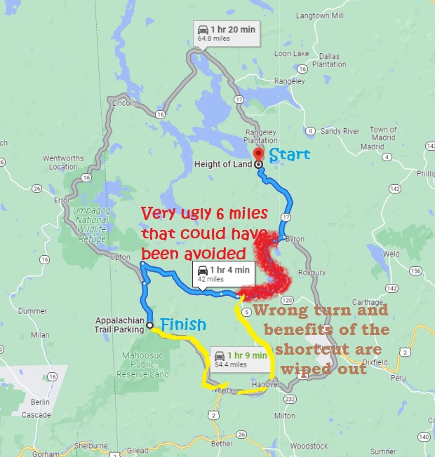 11:32 – ODO 212.7 +16°C – from Hight of the Land to Grafton Notch AT parking on route 26 in ME. Very confusing, treacherous, and unnecessary Garland Pond Road to make an imaginary shortcut to get to the begging of the trail. The road seems innocent enough in the beginning to lure you in but gradually deteriorates to the point that you wish you’d turn back. And when the worst was over in Andover, I made an erroneous turn into route 5 (to the North) and eliminated any benefits of continuing straight ahead to take E B Hill Rd. I ended up driving 49 miles instead of planned 42 miles the “optimal” (shortcut) way.
12:53 – ODO 261.8 +20°C. A slight pain under my right knee is troubling. That pain usually come on a second straight game day – usually on Sunday after a soccer game.
13:22 start the hike. Today I only would go a few miles to the shelter.
13:25 – a sudden decision to take a deviation and go see Table Rock. The intent is to explore side trails that I missed last time here – 2017-09-01 TH.
14:20 – first view from the top down to parking lot and route 26.
14:44 – I climbed the wrong dead-end trail appendix under the table rock, and now I must retract my way backwards with a heavy backpack. I tried to find a way forward, but deep crevasses are blocking my advancement. I will have to crawl backwards. But from here, from below it is the only good vintage point to understand why this place is called Table Rock. It is a giant slab of rock sticking out and hanging out of the slope creating a covered area underneath. This might be a good climbing place – not too far from AT and parking lot.
15:00 I am out the sticky situation and at the top of table rock. There are plenty of bugs attacking. I was sitting on the border of sun and shade as it is too bright on the sun, but too cold and buggy in a shade. How to explain myself that life is already started and with this speed it be over soon. The tail is not very crowded. 2 people met on the way her, and right now 3+1 day-hikers just waked onto the table rock. Group of 3 – they are tourist from Europe but speak to each other in English.
16:55 after 2.8 mi hike I am alone at the Baldpate shelter. I do not remember any particulars from 5 years ago. I even missed the turn to the shelter and had to cut my way through the bush. I have 3H for food and camp. And the pain under right knee is gone.
19:26 I am already in my sleeping bag. It is nice, warm and all the body is resting. The mosquito net is right here by my side in case they will not go to sleep as well. All my spare clothes and hammock used as a pillow under my head.
19:56 another hiker arrives late in the dusk.
20:14 – last pictures on the day – golden sun lights are dying on the lower tree branches. How did they get through the woods?
Navigate through the List
- 01 July 2022 trip to ME - between routes 26 and 17 (2025/06/29)
- 02 2022-06-30 Thursday - very treacherous Garland Pond Rd (2025/06/30)
- 03 2022-07-01 Friday - hike 6 AM to 6PM to cover 13.5 mi on familiar grounds (2025/07/01)
- 04 2022-07-02 Saturday - a dream spot at the end of the day (2025/07/02)
- 05 2022-07-03 Sunday - aspire to Upper Richardson Lake (2025/07/03)
- 06 2022-07-04 Monday - last 28 miles to the car (2025/07/04)
- 07 Travel Lessons and further actions (2025/07/05)
Be the first to comment