Day 02 summary: hike the Franconia Ridge in the rain and wind and climb over Lafayette and Garfield mountains.
06:22 wake up at Liberty Spring Camp. In the stillness of the morning allows highway to be heard vividly.
Forecast – cold looks gloomy – it is cold, and rain will start at 11AM till the evening.
07:28 start the hike
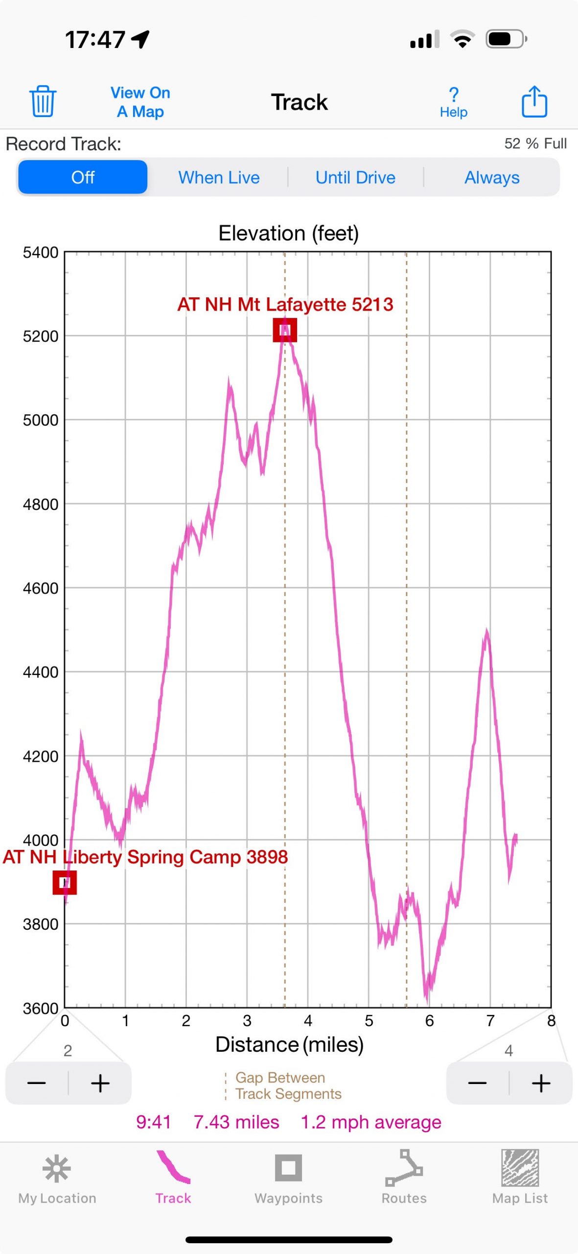
07:48 – I am on the Franconia ridge near the split between road to Liberty Mountain (south) and Lafayette Mountain (north).
08:35 – 09:02 I doubt if leaving the client in the middle of month-end close was a good idea, so I am notifying my partner who is covering for me that I will have a signal while on the ridge – please do not hesitate to ask any questions. Good! I am doing my Spanish Duolingo. One super-fast hiker flies up the ridge towards Lafayette. He is planning to complete all Whites apparently this weekend.
09:32 the first big mount from three is conquered – Little Haystack. Rain has already started, but my umbrella is useless – the wind is too strong on an open terrain. The views are still dramatic even with all the dark skies and rain.
10:05 – random stop to take a breather and eat an orange in the mist and fog (4861′).
I am trying to walk with one stick and an umbrella, but I slip and fall with a loud yell. The hikers behind me couldn’t believe that umbrella just froze in midair and then decided not to fly too far away. I stood up, walked back and picked it up just a few yards to the side of a stony desert.
11:06 – 11:24 I am at the highest point of the trip – Mount Lafayette (5260′), but I can’t stay here for long – I am beginning to cool off and there is a need to keep moving to remain warm.
12:51 – It looks like the rain is mostly over I am beginning to dry off. The trail is mostly downhill, so I need to be very cautious. For So far, I’ve met only 15 people – very low number for a very popular section of the AT. The miles are going very slowly, and although it is only 2.5 mi to the camp, there will be many grueling hours to get there.
13:53 – 14:27 a random stop at a height 3843′ – at spot that some might call a view. There is an opening through carcasses of dead trees on a cloud covered ridge that I just came from. At my previous rest stop 4 hikers were going up SoBo, and one of them confidently said that it would be sunny in an hour amidst gloomy downcast weather. And in 40 minutes it begins to clear up, and now indeed sun is out fighting a battle with dark speedy patchy stormy clouds. I stop and begin to dry all my clothes and even napkins on tree branches. The rain is promised in two sessions of 2H now and just before sunset. I do not open the backpack as it is covered with rain protector. Temperature is about 13-14°C. I can see 27 emails from work, but I do not bother to worry about that. This stop, although meaningless, marks a turnaround point in optimism. I can do it, and I will do it despite the weather. The highest part is now behind me, and I am drying out after cold endless open ridge.
15:12 a stop to eat some wild raspberries. Slim pickings, but sun is still shining.
15:28 – 15:45 I am at Garfield Pond. I managed to find a stone that shaped like a couch, but it is cold, and it is wet at a crease. Still, I take it because everything else is either a bog or moss. While I am launching 3 more hikers arrive and scramble around to collect and filter water from a muddy pond. The trick is to find access to water – the edges are very unstable and boggy.
16:25 – I am withing 0.25 mi camp forest protection area (FPA)
16:26 – I am on top of Moun Garfield (4467′). There is a cement square of some former structure without an entrance. Views are excellent towards Pemigewasset Wilderness. Dark clouds are just menacing and quickly cover the horizon with gloom. I must hurry to get to the camp before new wave of rain starts
16:47 – 0.2 mi to the camp. I am at the Garfield side trail. Someone’s glasses are on the milage sign. Rain started again. It will continue till 7PM.
17:00 – 4020′ – I was hopping down from stone to a boulder rather fast – faster than younger kids. By 5PM I’ve reached the side trail to a Garfield Ridge camp side trail. The tiny string of water is trickling – that is the water source. The side trail is going endlessly up, and the caretaker greets you with a book in his hand. No way around that.
 17:10 As soon as I entered the shelter the rain started for real. There are spots in the shelter, and I grab the spot on the second level. There are 2 more beside me on the top and lower level can sleep 5-6 people. I spread my bedding for the night, I put on warm clothes and now, I go back to collect the water and pay my $15 (17:42). I spend 6 min to collect 3 liters of water and then I return at 17:48. No too far. I then go to a Cooking Area with my backpack where 10-12 people congregate under the cover of a tarp. I do everything slowly. I boil water for the tea and for the Pad Thai. Everyone is interested in my titanium stove with alcohol fuel. I am the last one to leave.
19:47 – last pictures of the day in a semi-darkness. The rain has stopped
20:03 – 20:21 – I am writing my notes in the comfort of a dry sleeping bag on the second level of the shelter. Going out from a second level for nightly needs is a challenge if you do not want to use the light not to disturb others. For tomorrow it looks like South Twin Mountain (4902′) and after that long winding mostly down all the way to the road. Expensive Zealand Hut is 9 mi away from me – that is a good goal for tomorrow.
I am set here in the shelter rather comfortably – plenty of cloth of different softness under my head and neck. All my belongings are spread along my body to right under the slope of the roof.
Navigate through the List
- 01 Preparations for AT NH trip of September 2025 (2025/08/27)
- 02 08-28 TH - Climb to Liberty Springs (2025/08/28)
- 03 08-29 FR - Franconia Ridge in the rain and wind (2025/08/29)
- 04 08-30 SA - From Garfield Range darkening sky to Zealand hut (2025/08/30)
- 05 08-31 SU - Casual Zealand hike and lucky return to the car (2025/08/31)
- 06 Summary of three 2025 AT trips (2025/09/01)


Be the first to comment