
Summary: from Boston to NH, drop the backpack at Webster Cliff Trailhead, drop the bike at Pinkham Notch parking, ride 29 mi back to Webster Cliff Trailhead, hike from route 302 to just over Mt Webster.
04:38 Wake up in Boston without an alarm. There is a morning light outside. The night wasn’t like a night before an important flight. I woke up 3 times at 22:02, 00:40 and 2AM. The last-minute weather check – everything is OK – low 5-10% probability of rain every day except Monday. 12°C at night and 21-23°C during the day. The sunrise around 05:03 and sun set at 20:33.
05:11 ODO 0.0 – depart from home and drive nonstop to the beginning of the trail.
07:47 ODO 170.2 +17°C – arrived at Webster Cliff Trailhead. There are already plenty of cars here all the way to highway. I took backpack, walking sticks, water bottles and rolled tarp and hid in the woods where I would start the hike in a few hours. Tere is no signal. Mosquitoes are bearable – just a few. Pack additional food from home – porridge for tonight and 2 oranges. I am checking the list created yesterday what to take with me on a return bike trip – bright yellow coat, coconut water. The list is taped to the bag prepared for this voyage.
08:56 ODO 199.0 / elev. 2037′ / distance travelled from the beginning of the trail 28.8 mi. I arrived at Pinkham Notch parking lot on route 16. The lot is enormously long but almost all spaces are taken. There are a few and there is overflow AT parking a hundred yards prior.
There is no umbrella in the trunk. No worries. I am taking a small folding umbrella from my office backpack with laptops.
09:12 I am exploring the roots and connections between AT and the main parking lot. There are plenty of signs that West Branch bridge is closed and advisory to use a bypass.
10:01 Surprisingly, I have already ridden 2.6 mi on the bike. My first pleasant stop on a shady pull out. The road down to Glen promises to be fast and easy. I took $36 cash with my and one credit card for emergencies. I remembered to turn on the back blinker in the bike.
10:45 – 10:52 – elev. 543′ – taking a quick break in Glen in front of the Pro Tune bike/ski shop. Completed 12.4 mi, 17mi to go. A very loud entertaining train passed nearby behind the trees. The road is wide and shoulder is wide enough and convenient enough for the bike.
11:34 – 11:42 – elev. 677 – I am at Bartlett and I need to climb to 1275′. Completed 18.75 mi. Weather is perfect. The sun sometimes hides behind the clouds. Only 11 more miles to go. My speed on this second stretch of the road is very encouraging 9.8 mi.
12:09 – 12:50 – elev. 829 / I biked 21.65 mi. I am taking a bigger break to swim in a Saco River that goes parallel to the road. First, I drop the bike near the road, then go deeper into the forest towards the railroad. Next, I walk to tracks toward the bridge and descent the railway embankment to the river. Here I find some never-discovered spots with no obvious access to water. But there is no one around, and can take off and dry all my clothes, eat my grapes and orange from home, refresh and take stock of the situation. There are about 8 more mi to go.
13:30 – elev. 1054′. One more quick stop. Only 3.3 mi to go. I am at Crawford Notch Campground. My speed is very respectable, 8.2 mph. I am sitting in a shade with my back against the wooden fence. My speedy progress is surprising for me – it is not as hard as I imagined.
|
|
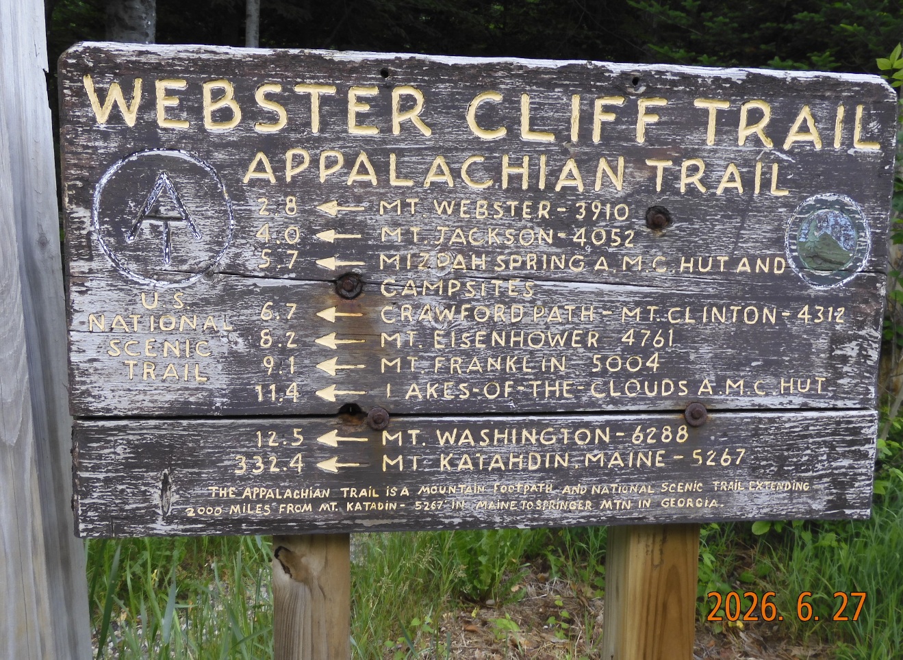 |
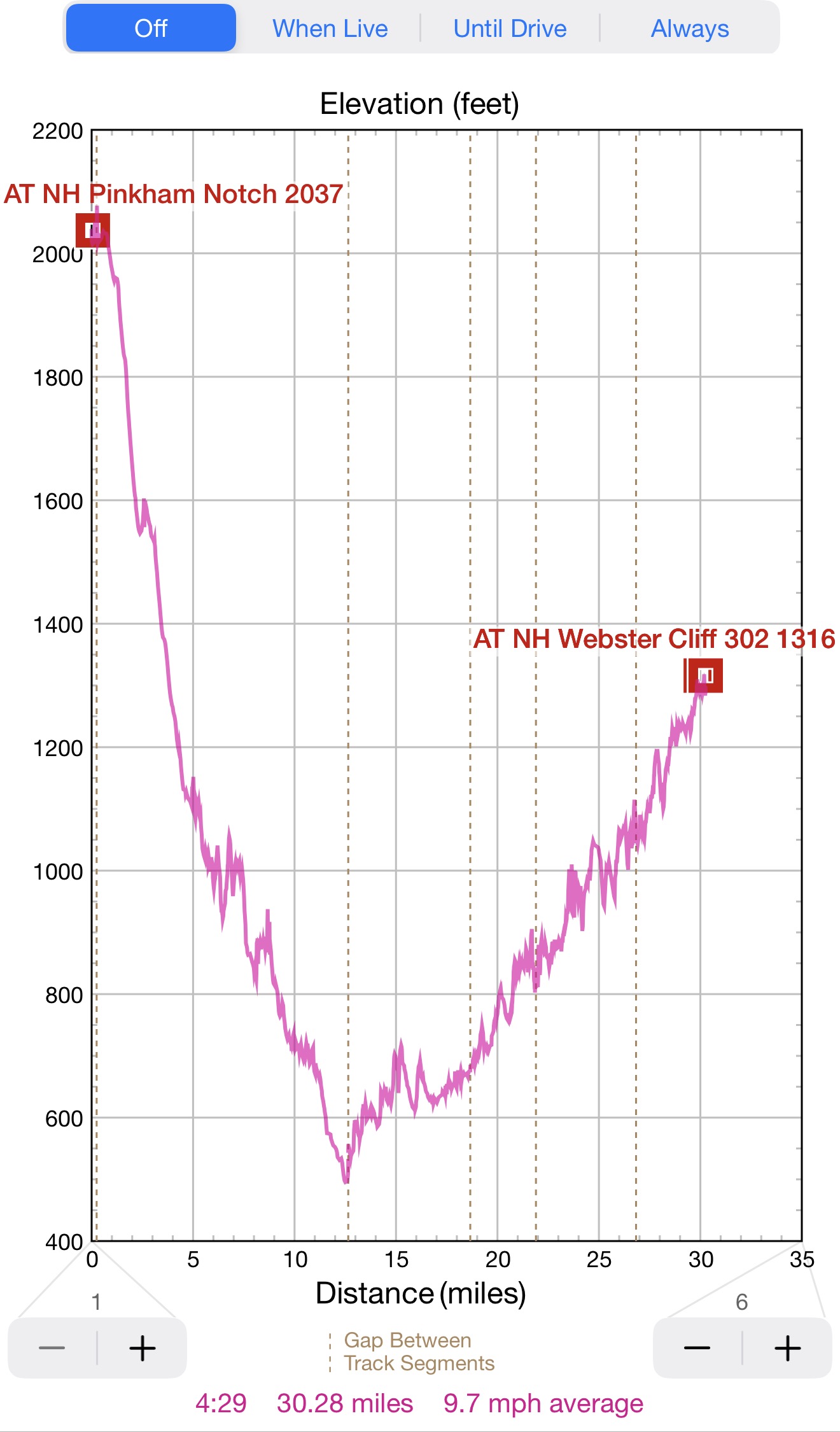
| Bike ride from Pinkham Notch to Webster Cliff – 12 mi down to Bartlett and 18 mi up the slope in over 4H | 12.5 mi to Mount Washington and 332.4 mi to the end of Appalachian Trail (AT) in Maine |
14:08 – 14:27 Wow! The bike section of the trip is done. So far, everything has gone as planned. I am hiding the bike at the same spot where I left the backpack. It looks like I forgot to dry out a plastic bag from May, and it smells awful. A good lesson for me for the future.
As for the hike ahead, it will a straight up adventure to reach Mizpah Hut in 6 mi.
15:25 It is tough going up and up from the valley (1300′) to the top of the range at (3800′). And without the contract extension from OTIS, I am losing one of the frames inside of me. Now I need to search for another foundation, for example 2 this trip. So far, I’ve hiked 0.9 mi and climbed to 2131′. I remind myself to simply go forward and enjoy fresh air and sound of nature. But it is hard.
15:58 Hiked 1.3 mi. It is extremely slow going. I am sitting on a boulder. 4.6 mi remains. I completely forgot to do my Duolingo and there is no signal now.
16:35 – 16:44 hiked 1.6 mi, elev. 3033′. It is a first cliff and a first view in a series of clearances towards route 302 below where I came from. Now I feel the wind is gaining and thinking to add some layers. As an incentive I eat a LÄRABAR very slowly stretching the sweet taste on my tang.
 |
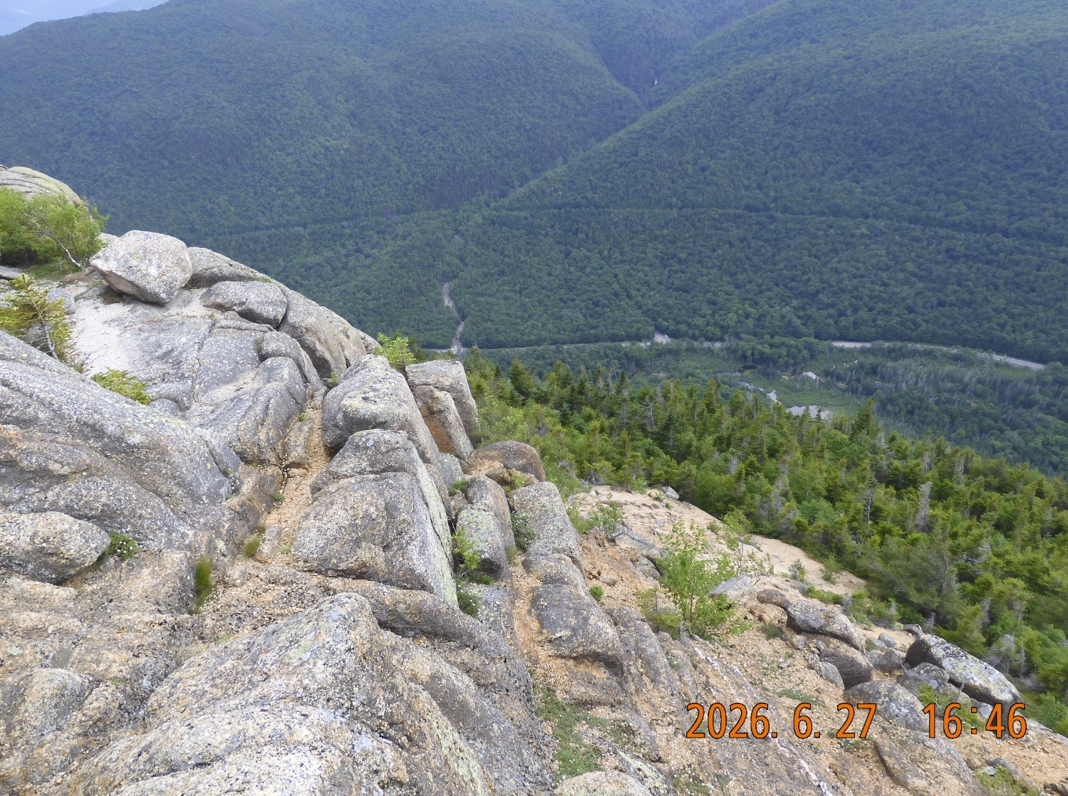 |
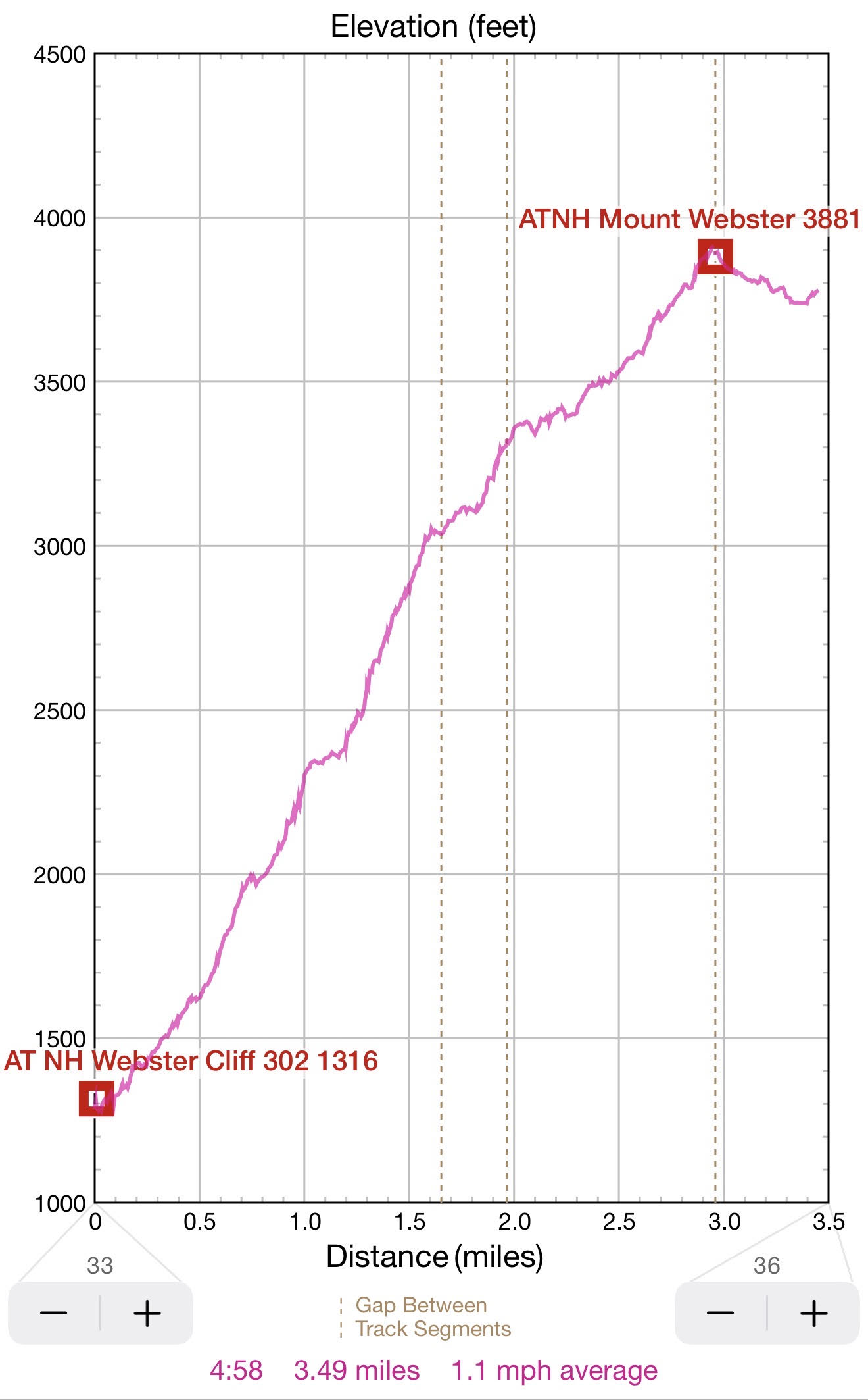
| From 1300′ to 3880′ in 3 miles – a tough hike for the first day | The reward is an access to multiple views down to route 302 all along the trial after about 2H of hiking |
17:06 hiked 1.97, elv.3305′. So far, I’ve met 11 hikers. I am on a second view towards the valley and Willey House Site with closeup to usual cars, kids, ice cream and boredom. But here on the slope the only option is to go and go forward.
17:21 I am hiking for 3h and done only 2.1 mi. Elev. 3388.
17:41 -2.45 / 3481′ The progress is slow and I constantly see in front of me next peak that is even higher than I climbed before. The only good news is that this section climb is very straightforward – just unrelenting up and up and up. And beautiful views down to the highway every few hundred yards. Endless, endless, endless.
18:04 – 2.73 mi / 3633′. Just 0.3 mi remains to the top of the mountain and impossible 3.1 mi to the hut.
18:35 – 18:59 – 3 mi / 3910′ – Finally, I am on top of Mount Webster. The trail makes a turn here and goes away from the road. From here there is a first good view of Mount Washington. There is good signal here – so I will do Duolingo for the whole day. That takes time. Also, I am sending a status update to Lira. From this point the trail levels up. The climb is over for now. As there is 3.1 more mi to hut, I will no
19:07 trail splits. AT continues north-east and Webster-Jackson Trail returns to the road. I am looking for a spot to camp.
19:26 found my spot for tonight. I wondered 60-80 yards away from the trail and found a nice, clear of vegetation, flat, mossy spot good for hammock but probably not for a tent. I will call this Camp Luminosity as sun lightens the scenery to the last minutes of the day.
There is a very weak signal that allows me to check the weather – OK, no rain
20:13 I am in my hammock. I am tired. The birds are singing. It is not very cold now, but I am getting ready for a cold night. I put on all the layers except for a bright yellow jacket. The flashlight on the forehead is ready. No cooking tonight – I am eating my porridge from home. Rainfly is flipped open for the light to come in. The sky is clear with some puffy clouds here and there.
20:33 sunset, but forest is filled with light – that is why I call this – Camp Luminosity.
21:03 Accomplishments today: 30 mi of biking in 3.5H and 3.5 mi of hiking in 5H. I am behind schedule, but I am already gained the planned height. All things are tucked away in a backpack.
Where would I end up tomorrow?
Navigate through the List
- 01 2026-06 Preparation for a third trip (2026/06/02)
- 02 2026-06-03 WE - Private Mile Notch Rd. to Grafton Loop Trail (2026/06/03)
- 03 2026-06-04 TH - from Old Speck MTN over AT to Mahoosuc mile (2026/06/04)
- 04 2026-06-05 FR - local shortcut to Bull Branch and alternative roots (2026/06/05)
- 05 2026 06 Lessons for all three May-June trips (2026/06/06)
- 01 2026-06 Preparations for the fourth trip (2026/06/26)
- 02 2026-06-27 SA bike fast without rucksack, hike slow without gusto (2026/06/27)
- 03 2026-06-28 SU Fourteen miles in fourteen hours over Mount Washington (2026/06/28)
- 04 2026-06-29 MO - up to Mount Madison and down to the car (2026/06/29)
- 05 2026-06 Epilog - bite the bullet and do it (2026/06/30)
Be the first to comment