Summary: drive from Boston to Golden Rd. in ME and drop the bike on an unnamed side road visible only from the satellite map. Drive back to Kokadjo on Frenchtown Rd. and park the car 11 miles into the road. Start the hike toward AT and East Branch shelter.
04:15 – Wake up on Boston without an alarm
Attach bike, load ice, water oranges and porridge from the fridge, check the weather forecast. Once again, the rain is expected today (35%) and on Tuesday when I might be already back home.
04:47 – depart in the morning at dusk +17°C
05:39 – entering New Hampshire
06:16 – ODO 99.9 miles after 1.5H of driving
07:11 – 07:38 – ODO 164.1 – service area in Gardiner, ME – between routes 295 AND 95. I am half the way into my today’s planned driving.
08:32 – 08:54 – ODO 219.6 – Hannaford in Auburn, ME at exit 157 – a familiar place from my previous stops here. I bought strawberries and blueberries and washed them in the restroom. I use their picnic table to eat the berries just as powerful rain starts and grows in power immediately as I pull out of the parking lot. Good timing.
09:53 – ODO 261.1 – I am in Moson ME at the beginning of 100-mile wilderness section of AT.
10:05 – ODO 271.7 – Greenville, ME – my last town on the way to wilderness.
10:27 – ODO 289.1 – beginning of Frenchtown Rd. near Kokadjo. The paved road will end in 2 miles.
10:51 – I made a mistake and took Sias Hill Rd. instead of a bypass suggested by Google. This road is unmaintained, full of deep potholes and in one place a river (a tributary of Bear Pond Brook) crosses the road over the top 5-6 inches deep. I measured the water depth with my bare feet and then drove through with trepidation.
11:35 – ODO 309.5 – +24°C – I am dropping the bike a hiding it in woods 1.1 mi into the side road. All the side roads look the same, but I know I am on the right road as I was using Google satellite map view.
12:04 – ODO 310.6 – I am back on Golden Rd. This time I will try a bypass to avoid the treacherous unmaintained road section.
12:53 – ODO 330.2 – I am back at the beginning of Frenchtown Rd. Instead of leaving the car here – a lonely unfriendly spot far away from the trail, I will drive into the wild and find a good parking spot to leave the car there for several days.
13:12 – ODO 337.5 – elevation 1136 – I am at the beginning of Public Lands. I thought of parking here, but no. I will keep going deeper into the forest.
13:38 – ODO 341.3 – elevation 1552 – I am at a cozy parking area for 3-4 cars between First and Second West Branch Ponds a few steps short of West Branch Pleasant River and the bridge. It means I shaved off 11 miles of pointless road hiking for today, but that adds to my biking routine when I will be coming back from Golden Rd. Another bout of rain starts and goes. I have patience. I will wait out in the car, trusting the forecast.
14:08 – let the hike begin. Instead of 16 miles of hiking we are now expecting only 5 miles to go today to the nearest AT shelter.
14:40 – my road quickly deteriorates into a boulder washout, but soon better and clearly maintained road joins from the left and this road is obviously used by logging trucks. This road – Medaw Island Rd. or Smithtown Rd. – branches out from Sias Hill Rd. above (to the north of) the First Roach Pond and it is clearly established and even visible on Google satellite map.
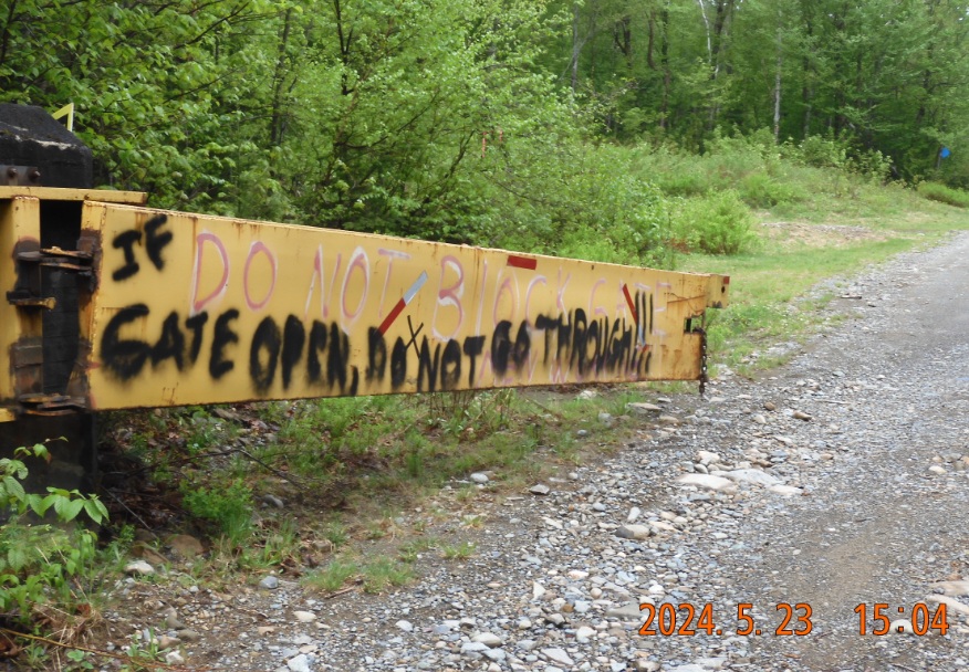
15:04 – the famous super heavy duty yellow gate with a handmade warning – No parking at AT and with ugly graffiti – “If gate is open, do NOT go through!!!”
15:18 – I am at AT, where this road called Logan Brook Rd. Despite this section being called 100-mile wilderness, several private roads cross the AT creating re-supply and re-entry possibilities. There are 1,8 mi to my shelter from here. Bugs begin their sticky attack, and they mean business. I cover myself with bug spray making our fighting chances more equal. The last time I was here – it was on a first 10-mile wilderness trip on May 29, 2021, at noon. It was a Saturday.
16:39 – target for today is reached – the East Branch shelter. No one is here and no one I’ve met so far. And the bug situation here is much more comfortable – just a few stragglers. Seems like everybody forgot about this place. Very good! No cell signal.
17:38 – the campfire is set as preparations are under way. Two 78 years old hikers (from the Carolinas) walk right in doing a significant wilderness AT section to Monson moving south bound.
I set up my hammock not in the shelter, but a few yards away for better privacy. We hang the food high in the air. I need to practice more attaching a stone to the end of the rope and throw it over the healthy-looking branch to stow the food away from mice, chipmunks and primarily bears. My skills here are non-existent as I rarely have smelly foods. All is nice, going according to plan and very quiet.
20:05 – for supper – porridge from home. I couldn’t even finish it and water from home. No tea. One of the hikes fell into the water when he was filling the bottles, and now my campfire has gained new significance – to dry all the wet clothes.
20:13 I go to sleep in the hammock. It is going to be a cold and clear night.
Navigate through the List
- 01 May 2024 preparations for the trip (2025/05/22)
- 02 May 23, TH - substitute Frenchtown Rd. hiking with driving - smart (2025/05/23)
- 03 May 24, FR - 15 mi of hiking from 6AM till 5:30PM (2025/05/24)
- 04 May 25 SA - it is a lakes and streams country (2025/05/25)
- 05 May 26 SU - Does the path to Golden Rd. exists? (2025/05/26)
- 06 May 27 MO - the magic and anxiety of the last miles to the car (2025/05/27)
- 07 May 2024 - Final thoughts (2025/05/28)
Be the first to comment