This was the only sunny and even hot day of this trip.
Wake up at 7AM. As today will be rain-free, I will put on old boots and leave new boots to dry out on sticks all day in the camp. Large new back pack all this time just having a vacation in the tent. No action for new backpack, but old small day backpack everyday see food, water, dry socks and photo-camera with fresh battery loaded. Today, additionally I am loading all the tools – this is the first load that destined to go back to the car permanently.
07:35 – 07:49 – I am building a bridge that will link me with the “mainland”. The trees prepared yesterday are a perfect fit.
I found the bike OK, but the front storage bag is still all wet. I’ve check the tires and promised to put more air in it when convenient. Ride bike back to car and have a watermelon breakfast on a rusty pipe on a road side. I had to eat far away from the car, so that all the juices from watermelon would not mess up the car. As soon as I finished eating and was walking back to the car with my machete, table cloth and remaining watermelon, I saw a car pulled up. It was an older gentleman with his dog. They parked behind me even closer to the closed bridge. He was as surprised to see me, as I was surprised to see him. I offered him a quarter of watermelon, but he refused. They started walking away beyond the bridge on the closed section of the road.
I needed to pack the watermelon very tight and snug into the cooler without any ice of cooling. Remaining 2/3 of it must survive till Tuesday. I would finish the last of this watermelon already at work in Farmington, CT on Wednesday, May 31.
08:58 in the car- ready to depart – odometer 228 miles. It means that my Friday’s back and forth trip was 25.5 miles long. Temperature +16.5°C
One super quick stop to a promising big road, but the mini trip ended almost immediately. All it was – two giant fire pits snuck away from main road. And I was hoping to find an exciting and easy back road shortcut to Jericho Park, but found an illegal camping spots.
I did check the weather forecast and it showed 100% chance of rain for tomorrow, Monday, May 29.
Slowly a plan formed to take a 10-mile loop with starting and returning points separated by 2 miles of nice road.
~09:55 Deposit bike at the beginning of Mill Brook Tr. Just in case I will return on this trail. This point is 2 miles away from Unknown Pond trailhead. I did notice a dark blue Prius parked fist in a row of cars while I was parked there to unload my bike.
By 10 AM I reached parking lot for Unknown Pond and started my hike. I am covered with sunscreen and bug spray.
10:07 Started. This is a very gentle and uneventful hike. You slowly gain elevation without even noticing it. Trail follows the river upstream, so you constantly hear the brook ramblings. This hike was such a difference from yesterday’s “fight for survival” that I called this trail “Relax to Unknown”.
The main attraction here is foul smelling blooming trees with white flowers whose beauty I was admiring yesterday. Today, with full sun strength they stink as rotten eggs. At first, I even thought that the smell has something to do with me or my clothes. But one attempt to smell these flowers removed all doubts – it is them, not me.
Another entertainment – trail crosses the accompanying river several times, but mostly proceeds on Eastern bank of the river. You see mostly retuning hikers in groups of all sizes.
11:56 Under 2 hours I covered 3 miles and gained just under 500m of elevation. According to GPS I travelled 3.3 miles and the next leg should be 2.2 miles.
11:59 There are organized free 5 tent sites here with a toilet and one central fireplace. Plus, people carved out several illegal sites all over the pond. Just as I was examining the sites, a ranger was diligently cleaning the bathroom. Amazing. I thought they just kept clean by people themselves.
Pond itself is a medium size quiet water body surrounded by evergreens and with a backdrop of The Horn (3,905′).
There are a few hikers and rangers here. Some sites are taken. But during remaining 2 legs of the loop
There is 2.8 more miles to go for Mt. Cabot.
I will continue my loop on Kilkenny Ridge Tr. towards Roger’s Ledge.
12:24 – resume the hike. Trail goes up a little bit (from 970m to 1015m) and then starts to descend all the way to the next valley (about 725m).
 |
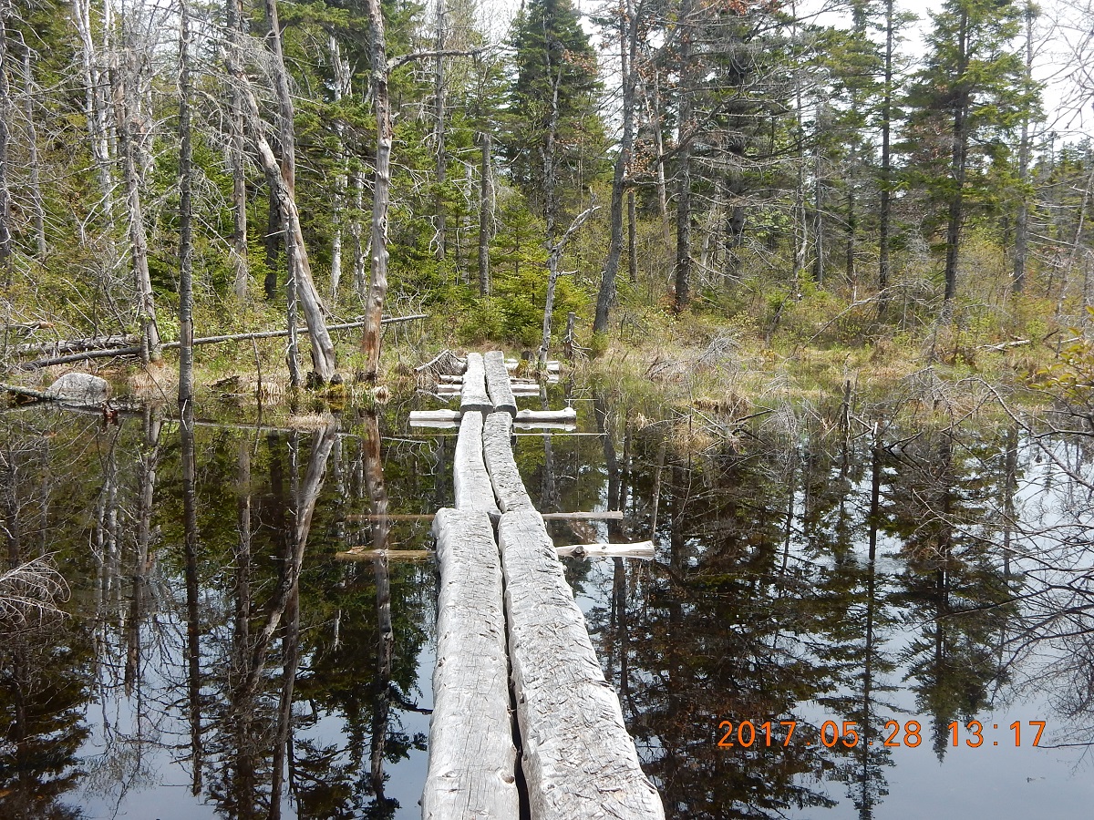 |
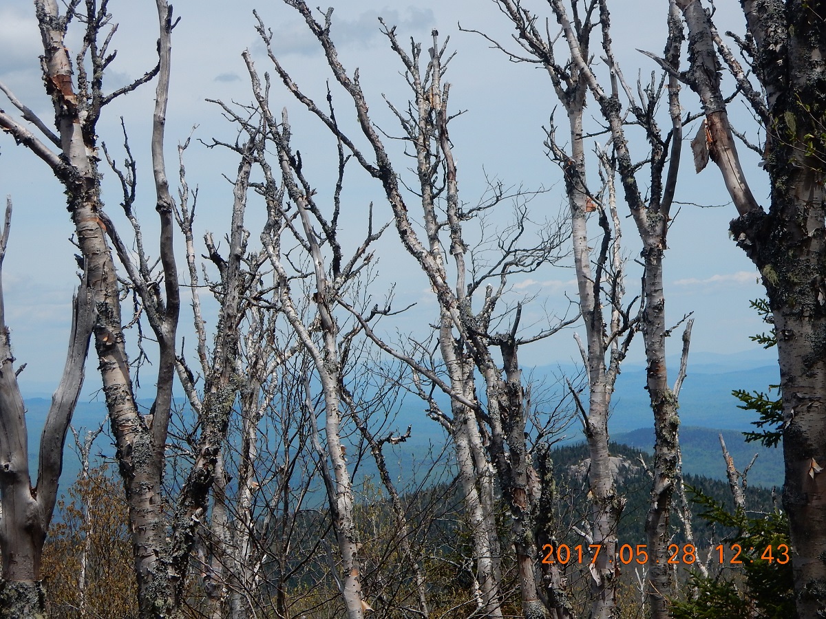
| 12:43 – I am entering a large section of dead birch forest. Carcasses of dead branchless birches are standing guard as remaining damaged trees are slowly dying either from disease or infestation. During my other trip to Wild River Wilderness I discovered similar opening | 13:16 Reached another beaver pond or beaver habitat called Killback Pond (I’ve learned about this name later while writing this blog on TUE 06-13). I’ve registered absolutely no desire to swim at this point of the hike. Here trail goes on slightly trimmed tree trunks right across the pond and is held above water by stacks of wooden frames layered on the pond floor. Beavers appear to use this wooden path just above water level as a “natural” border and build their dam up against the path. Water is very clear and transparent. |
Right after the pond, I’ve met a couple of hikers and the man was wearing blue top and red shorts. I commented that we dressed very similar, but in reverse order, and we are going in opposite directions. We laughed, and I did not pay any attention to this rendezvous. These were the only hikers that I’ve met for the remainder of the hike.
13:38 – 22 minutes ahead of schedule, I’ve reached intersection of Mill Brook Trail and Kilkenny Ridge. I did not check specifically, but there are no obvious visible signs of old East Branch Trail (marked on some older topo maps) going north toward Mill Brook Road.
Instead of turning back toward Hatchery, I continued straight, tempted by a sign to Roger’s Ledge promised in just 0.6 miles.
Another free campsite is just 100 yards away, but I did not explore it. For some reason, the whole area is not very romantic – too open and too closed all at the same time. Environment is somehow torn by previous events, so nature did not have time yet to repair it natural beauty.
First 0.25 miles seemed very long (a posted sign – Leaving Forest Protection Area), and I figured I just need another .25 and another 160 meters to make it complete 0.6 miles. Funny that I already completed 5.5 miles and 3.6 pending, but these 0.6 x 2 = 1.2 miles are the most turbulent.
Next 20 minutes were a mental struggle – go on or turn back. Trail would go very sharply up sometimes turning into a stone staircase.
Then you reach the bottom of the ledge, and wonder if this is it? No sing or place to rest. Only an endless wall going up to the skies. OK. Let me go on just a little bit more. Let’s see what this Roger’s Ledge is all about.
14:02 – arrive to Roger’s Ledge – 914 m. Good view, sunny and windy spot – good for drying clothes and socks. Linked up with Lira to tell her my location and plans.
Checked weather forecasts. The bad news was that it will start being miserable from 8AM on Monday Morning, but the good news is that I will break the camp on Tuesday morning under cloudy, but not rainy skies.
This ledge will be the northern most point of the trip – 44°33’0.3″N 71°21’42.0″W
14:34 still at the Ledge
14:52 arrive back to the cross road of Kilkenny and Mill Brook trails. The whole deviation took 74 minutes, but without it, the whole day excursion would not have had a high point in it.
Now I had 3.6 miles to go back to Heathery. And great determination to slide through these 3.6 mile in no time. So, I started to note measure covered distance every 30 minutes. At 15:30 (first 35 minutes of the run) I had 1.3 miles. At 16:00 I covered 2.6 miles and finally at
16:14 I emerged on the other end at the hatchery. Now, the plan was to mount the bike and ride 2 miles back to the car, but just as I was escaping the forest I saw a bright red car dumping hikers and quickly disappearing – this of course were my only “companions” of the trail back at Kilback Pond. They took the same loop as I did, but did it in an opposite direction. They walked most of the way back to their car from Unknown Pond trailhead, but someone offered them a ride for last half of their walk. Now, they in turn offered me a ride to my car. It would be a completely extraneous 2+2=4 miles loop for them, but I guess that is how earth revolves. Wow! I said – “it pays to be Red and blue”. By now I already changed my colors. I put blue shirt on top, so I was blue and blue. Timing on this chance meeting again occurrence was beyond spectacular. We both acted completely independently from each other. We both made decisions that slowed or speeded up our progress on the loop. I passed many other hikers whom I probably would not even remember if not for “blue and red” comment that I made. This was not the matter of minutes, but literally seconds. Few seconds earlier or few seconds later would have made this chance encounter impossible. Another incredible turn of events.
They drove the same very dark blue Prius that I’ve noticed when I was unloading my bike here. While in the car, we talked about who is from where, and it turned out they are both working as nurses in local NH hospitals. Just imagine, at 16:16 I took a picture of my bike, and 9 minute later at 16:25 I have a picture inside my car (+22°C 240.9 miles on odometer – 13 miles from camp).
16:59 I arrive to my closed bridge +18°C – 253.8 miles. Sky is already covered with clouds and storm is gathering on the back ground.
17:33 I crossed the river and just slightly adjusted logs in my bridge.
This time swim was in order. Your body just love to cool down at the end of the long hike. Today only I will take a swim. No boot diving is allowed here as yesterday.
Supper – Today I decided to mix half KNOR’s Spanish Rice and half of vegan healthy meal from REI. That way I will lower the salt intake, while boosting the taste. And I will eat the second half of the mix tomorrow.
Today, on my fourth evening in the wild, I would pull all the stops to be comfortable. First, you bring everything you might need around you. Then you create an area to sit right on the ground with your back to a tree. To create more comfort and cushion, you can use walking sticks poked into the ground with an appropriate angle for better back support. For every pot and cup that can be upset by clumsy moves you create a support socket from sticks and stones. Now you can just sink comfortably against the tree trunk and hug a large boulder in front of you. This boulder will serve as a table [ 06-13 TUE 17:00 ] even if uneven.
20:11 – 21:37 – normal log time. Writing in a comfortable pose with support of a pillow and tent itself. The new tent – a gift from Tufts Health Plan to Lira on her 10-th work anniversary – is very good. We received it right at FedEx post while returning from Canada on July 9, 2015, but I never had a chance to use it as we switched to hammock in May 2016. What did I do for Labor Day weekend in September 2015? It is good. It is Coleman Go! Dome Tent ($110) Despite the strong and long rain showers, there were absolutely no leaks and it provides a good resistance to wind and no tears from sharp branches and thorns on the ground.
This evening everything is quiet and nice, and frogs just drowning the place with their songs, but tomorrow it will be rainy and cold again. I do not care, I think I am ready.
The very last occurrence of the day was that I suddenly realized what could have fallen out of back backpack pocket that I discover wide-open when I arrived to the camp. I clearly saw that how I put there the spare battery for iPhone and probably forgetting to close the pocket? Maybe. The only logical place where pocket might have opened was while I was depositing the bike into thick bushes. One of the branches probably get caught into the loops and pulled on the zipper. Anyway, I will not worry about this today. Tomorrow, in a bright daylight I will go back to the bike and examine the underbrush there.
Navigate through the List
- 01 NH Trip May 2017 - Preparations for the trip to Bog Dam Road (2026/03/09)
- 02 Thursday, May 25 - Drive, Search, Camp and Rain - Perfect! (2026/03/10)
- 03 Friday, May 26 - Remarkably Unremarkable Bunnell Notch Tr. to Mt. Cabot (2026/03/11)
- 04 Saturday, May 27 - Visibly Invisible Trail (Hunters Pass) to Ice Gulch (2026/03/13)
- 05 Sunday, May 28 - Relax to Unknown Pond (2026/03/14)
- 06 Monday, May 29 - Mud, jaws, bridge and rain (2026/03/15)
- 07 Tuesday, May 30 - We are so distracted by day job from our trail lives (2026/03/17)
- 08 May 2017 Bog Dam Road trip - Lessons learned (2026/03/18)
Be the first to comment