- This topic has 0 replies, 1 voice, and was last updated 5 years, 10 months ago by
Udar Gromov.
-
AuthorPosts
-
2020-08-19 at 15:22 #7918
Udar Gromov
KeymasterSummary: from Lower Cold Rive r Rd. to Governor Clement Shelter, then up to Killington Peak and Cooper Lodge, and then down to Pico Peak and Churchill Scott Shelter.
Woke up at 07:18. Gorgeous! The world is lit by the sun one more time. I am alone, so I can my time and have breakfast right here. I do not have to rush away from the crowds. I am already at peace.
09:06 after all morning procedures and hot breakfast -Wow! – vey close to be ready.Sector 1 09:35 – 11:05 = 1:30 3.19 mi (2.2 mph) up from camp to Gov Clements stone shelter
First 0.24 mi going through the light forest without any trail. But that is what makes my camp so secluded and tucked away.
Just as soon as I start walking on the trail, I pick up from the ground a light green selfie stick without any brand name or any marking whatsoever. I never used these, as both iPhone and camera have self-timer feature.I am finding this stretch of the trail very fun and inspiring. Trail was moved recently because of wild forces of the Servant Brook. Steep riverbanks are newly formed by the torrent, but for now it is a peaceful brook at the bottom of a deep cavities. Giant trees are still lying down toppled and upside down. You can see earth content dozens of feet down. You can see how thin the fertile layer is and how much earth matter was carried away by relentless water stream.
While admiring one of such deep earth cavities, two hikers are passing me by. They started today from Minerva shelter at 6:30 AM. That is 10 miles away. I was there at 12:15 yesterday. Time is probably around 10:35, but we will meet again at the shelter and they will bypass me at 12:35 on the Killington climb. And one more time they will catch up to my “super-human” speed at Cooper Lodger around 2PM.Trial here makes sharp turns away from the destroyed sections but returns to the brook repeatedly. You cross the brook 5 or 6 times. You cross 2 decent rods, walk over a new bridge, cross one ski mobile trail.
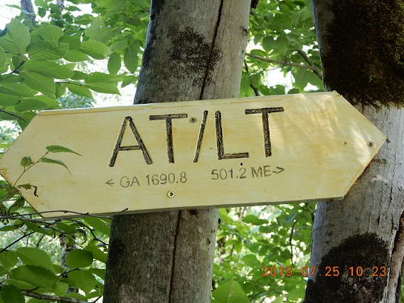 Upper Cold River Rd has a distinction to be 501.2 miles away from Katahdin in Maine and 1690.8 from Springer Mountain in Georgia. To make it more memorable someone placed a “Katahdin 500 miles” marker to make it more memorable.
Governor Clement Shelter is very large stone shelter with a fireplace! But it is very dark inside. Shelter is located perfectly on the trail with some road access, but it is tucked away so it is cozy.
I arrive here after two young hikers and depart before they do.Sector 2 11:30 – 12:35 = 1:06 2.15 mi (2.0 mph) from shelter to 3,250 ft – random spot in the forest incline
This next section will be an over 2,000′ climb from current 1,900′ level to 4,235 at the peak. I was trying to get a head start on a 4.2 mi climb to Killington Peak. So far today I have completed 3 mi and I have 7 more mi to go. That is the plan.
11:30 – I stared North on a Catamount trail that is a road at this point. After about 0.3 mi. AT/LT depart from the road into the forest and moderate and reasonable incline starts
12:02 – I hear a loud persistent bird call ahead. Too loud and to repetitions. On closer examination it is a volunteer moving a large stone with a rope ratchet puller. If you ever wondered how large stone are arranged and installed along the trail – that is probably how. They move them with a rope, chains, and a lever. The whole device is like a winch, but instead of a motor, a long handle is used as in a car jack. So, this screeching sound was from a lever and can see that a stone clutched by a chain already moved good 3 feet. The volunteer used a tree as an anchor, and he was planning to place the stone as solid step down the trail. All this is fascinating for me as stone is generally very hard to move, but here one person moves them (albeit slowly) to a desired position.12:04 – I hear the voices of 2 hikers, whom I left behind at the shelter, and decide to keep a good pace to keep them from passing me by at least till 12:30.
12:33 – I did kept a good strong pace, but I started talking to a south-bound hiker and 2 hikers overtook me. I have learned that the best water ahead is at Cooper Lodge near the top, and that I should get water there, because water at Pico Camp is miserable. Good to know!
Anyway, it is time for a quick break – I am at 3,284′. Another 1000′ of climb ahead. But it all very gradual and moderate. % mi complete, 5 to go. It very quiet and very tranquil in the Summer forest today.
Sector 3 13:02 – 14:21 = 1:19 2.00 mi (1.6 mph) up and up to Cooper Shelter – 3,387 ft
13:26 – after 2.7 mi climb Shrewsbury Peak Trail departs, and it appears that trail name is misspelled on the sign. It reads Shewsbury Pak Trail.
14:17 – I am at Cooper Lodge, but to get to the peak you need to climb on a side trail 0.3 mi. I see two hikers that passed me at 12:33 once again catching up to me. Interesting, where did they go? Why did not I see them? Maybe they explored or got lost on Shrewsbury trail?
I was worried that it will be up and down climb, but it was just long very gradual assent with just minor fluctuations. Anyway, I am here, and it is time to lose the backpack.Sector 4 14:32 – 14:50 = 0:17 0.22 mi (0.8 mph) last jump to Killington without backpack
This 0.3 – 0.4 climb is very steep, and you are gaining significant elevation. I took with me only TJ bar.
14:57 – 15:07 – I am on top of Killington Peak. There are no bugs, but plenty of vacationers from a resort on top of the mountain. Total number of people at the top is about 20. The mountain itself is way higher that all nearby prominences and offers great views in all directions.
On the way to the top, I found an Adidas cap, but no one claims it. That will be a good gift for Lira.There are plenty of radio towers and equipment on top here, but people are restricted. Moreover, there is a sign that reads: “Radio frequency fields beyond this point may exceed the FCC general public exposure limit”, but later web check reassures that ” the possibility that … general public could be exposed to RF levels in excess of the FCC guidelines is extremely remote” (https://www.fcc.gov/consumers/guides/human-exposure-radio-frequency-fields-guidelines-cellular-and-pcs-sites).
There are 2.5 mi remains from Cooper Lodge to Pico Camp and it will be all downhill. I will replenish water here, so my backpack will be a few pounds heavier. Next shelter – Churchill Scott is marked as 4.5 mi away.
Sector 5 15:36 – 16:50 = 1:14 2.40 mi (2.0 mph) from Cooper down to Pico Camp trail
15:41 for day hikers, there is a Bucklin Trail from a Wheelerville Rd. in Mendon, VT. Only 3 mi from parking and civilization.
16:49 – I am at Pico Camp side trail. It is another 0.5 to the shelter, and some hikers mention that it might be padlocked. I do not want to deviate a mile on a side trail, when I can simply continue down
the trail, reducing next day hike. In two miles it will be next shelter. Full speed ahead then.
16:58 – cell signal is so good here that I was able to have 2 min WhatsApp video call with MZ. He created a first video blog in a series from the gates of a prison where Putin detains Furgal (Khabarovsk governor). Interesting idea. But can MZ follow through?Sector 6 17:03 – 18:00 = 0:57 1.86 mi (2.0 mph) down to Churchill Scott Shelter
Total hike 8:25 – 12.15 mi – 1.9 mph – over Killington Peak
17:58 I have reached the Churchill Scott Shelter. It is 12 mi hike for the day. I am alone here – Great! Water is from a spring, so once again it is just a puddle in the ground, but it is clean and cold. Shelter is voluminous, but there is not table. I am spreading all my cooking stuff on the edge of the shelter.
18:43 – I am drinking unpurified water from Cooper Lodge. Beginning to cook my food. Meanwhile, preparing the bad for tonight.
19:05 – dinner today – PP Organic Green Lentil Soup. Some stuff is falling constantly from surrounding trees, and that creates a rain like sound. Target for tomorrow – route 4 is slightly audible. Flies are calmed down. A runner girl suddenly appeared form the trail and asked if I saw anyone. Nope. And she is gone.
19:44 – soup is almost over. It is warm, so I just in shorts and t-shirt. A poster slogan came to mind: “Thank you, essential worker Donald Trump!” -
AuthorPosts
- You must be logged in to reply to this topic.