May 28, SAT 05:07 First attempt to wake up. Although I went outside, but warmth of the sleeping bag called me back. It seems there is no rain.
At 06:29 we both wake up. Yes! There is no rain!
07:55 start hiking towards Mount Success.
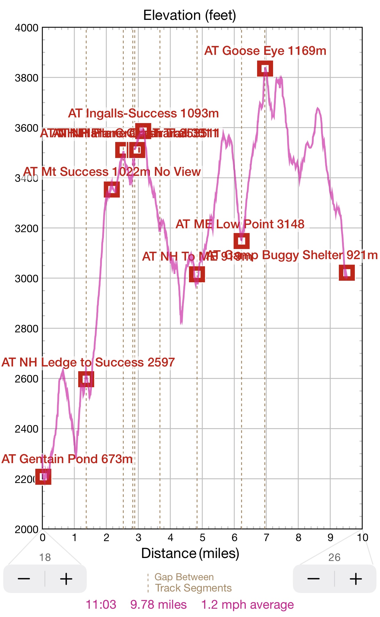
09:11 after two climbs and one descend, I am still at the same height as at the shelter. Now we have to do a serious climb to Mount Success. There is a signal here, and rain is possible 30-50% from 1 to 4PM. Good. And tomorrow will be sunny. Very good. Today I will be crossing into ME and there are 3.1 mi to the border.
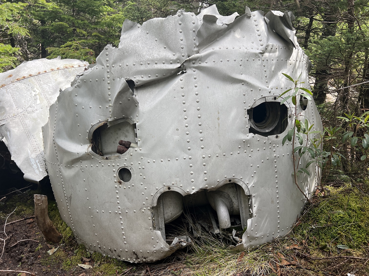
10:43 After 2.5 mi I’ve reached a side trail to a plane crash site. There are two hikers here, who already visited the site. I am dropping the backpack and cautiously proceeding on a narrow trail.
11:00 – very impressive. There are large pieces of the body of the pale and one wing. And where is the other? On November 30, 1954, a small turbo engine plane lost control and crushed into the woods near the top on Mount Success – irony. 8 people on board. They had to spend 2 horrifying nights into the wild, until on December 2, six survivors were found and rescued. Two, including the pilot have died from injuries and the cold. I started walking around the site enlarging my circle of investigation. I dropped a few feet to find a stone cove or grotto with ice and snow in it. And close to it – the second wing – much less visited. You can made out large numbers 160 written on it in a blue paint. Very interesting site to roam around and explore.
 |
 |
| We saw an injured plane on the ground. It fell from the sky onto Mount Success and in 1954 and was there ever since | The ups and down or early morning was just the beginning of a culmination at Goose eye at about 3800 ft. |
12:07 – I am at the top of Mount Success, and that is not the highest point for me today.
12:33 – I’ve hiked 3.9 mi. Now I am passing a side trail to Success Pond Road, where I was traveling on the bike 2 days ago. That is the last NH section before ME. I am 20 min behind my 2017 itinerary at this point. Encounter just one group of 4 young people who also planning to visit the plane crash site.
Down and up over steep slopes, holding the tree trunks so not to fall. Treacherous business. And endless. One slippery slope after another with very little break in between. Over an hour for 1.16 mi of gain.
13:52 – finally the NH to ME border. 16.5 mi done from NH road, 14.5 mi to go to first road in ME. Just one LARA bar today at crash site and there is no appetite for more food. All thoughts are focused on finishing the track today.
14:29 – first side trail in ME. Very tough going. Squeezing between two boulders. Last time (5 years ago) I had to take my backpack off. This time, I just balanced myself out by stepping on both hands. Sign shows 4.4 mi remains. I must climb the biggest mountain yet – Goose Eye (3,835′).
Last section before final climb was flat, and I stepped into hidden puddle – I just did not expect such a deep mud. And the very last yards before the summit are very steep. So steep in fast, that you need to use installed metal staples – like a ladder.
16:27 Ok. I am at the top. Suddenly, cold wind brings dense fog, and it feels like rain. However, there is a cell signal, so I can transmit my coordinates. There is 2.6 mi remain to shelter. As far as I remember, it will be up and down again.
17:14 In a dense fog at the top of second peak I’ve lost the trail, tried to re-trace my steps, and by mistake I started back on the trail where I came from. Quickly, I’ve decided to check my bearings and realized the error. I even made a screen shot of my wonderings.
This next section of the trail goes through flat mounts. There are plenty of oversized hidden puddles that is impossible to bypath. I would go right through disregarding the wet and mud. But the general mood is almost going up. I am getting closer to the target.
There is no lack of Puncheons (bog bridges) here on this section of trail, but they are in places where they are not really needed. Not loved section of the trail, not loved at all.
19:00 I am at the shelter – Full Goose Shelter. All alone. And there is a cell signal – yes!
19:14 Boil water. Cook food. The sun will go down in one hour.
20:31 I am turning on the light. Here someone left oversized Crocs that I can wear right on top of thick woolen socks. Chili is cooked for diner. Today hike was from 8AM to 7 PM – 11 hours to cover just 9.78 mi. It was a tough going crossing from NH to ME.
Navigate through the List
- 01 A brief overview of May 2022 AT trip (2026/05/18)
- 02 May 26 THU - Ride the bike without the rucksack (2026/05/19)
- 03 May 27, FRI - hiking from Gorham, NH to Gentian Pond Shelter - again (2026/05/20)
- 04 May 28, SAT - hiking from Gentian Pond to Full Goose Shelter (2026/05/21)
- 05 May 29, SUN - Mahoosuc Gorge - miracle of traveling pants (2026/05/22)
- 06 May 30, MON - hike over Mahoosuc Arm and Spec to car (2026/05/23)
- 07 May 31, TUE - drying out and resting up (2026/05/31)
Be the first to comment