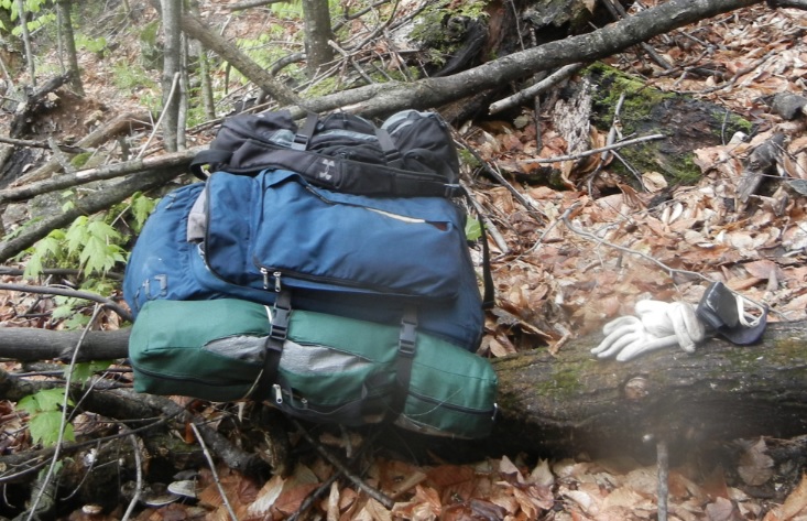
I never carried the “full house” on my shoulders before. This time, with introduction of an old professional-grade KELTY backpack I would carry a tent, and sleeping bag, and warm clothes, and food, and tarp, and poncho and dozens of other small, but very necessary things.
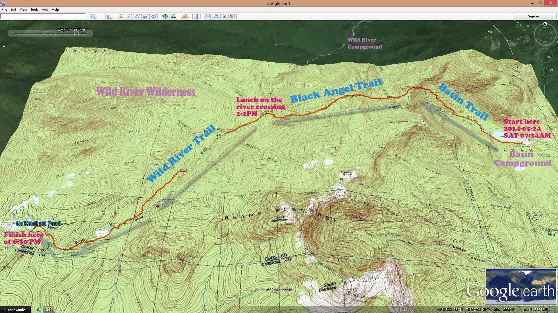
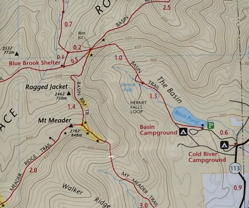
I woke up around 6AM, and I was folding the tent and gathering my things until I was finally ready. At 07:38, I started to walk on Basin Trail. First thought was that no way on earth I can carry this beast of a backpack. On the second thought, how other people carry all their hiking possessions and do not complain?
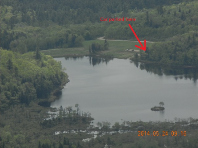
Almost immediately off the parking lot, I made a couple of fantastic shots of the Basin pond, but I did not know about the lucky pictures until Sunday evening, when I would review the “catch”. Weather was cloudy, but not terrible. No rain. Even some breaks in the clouds.
I have reached very first river crossing at 8AM. Here it means removing the shoes and socks, and crossing barefoot with a stick in your hand for stability.
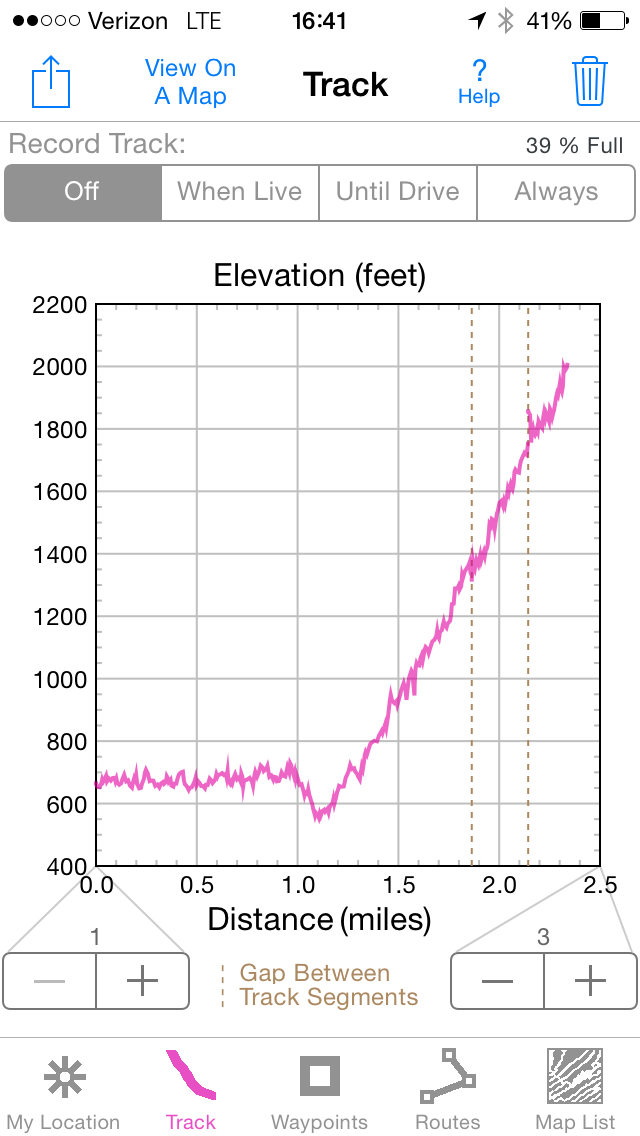
My first landmark was 2.3 miles away at the top of the first ridge – Rim Junction and I would climb there from 662′ to 2012′. This was by far the most difficult portion of the hike. I was still getting use to the weight of the pack, plus steep climb, plus uncertainty of the two-day path ahead.
At Hermit loop (08:39) I caught the last fleeting Verizon signal, and was able to send one last email, that I have started on my itinerary, and everything is OK.
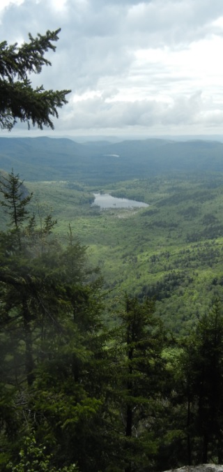
Trail suddenly went sharply up and dived through the rock formation into some flat plateau. I have reach the rim junction (2.2 miles) 10:16AM. This is 2 hours and 38 minutes into the hike. My speed was not great with frequent stops and hesitations. Basin is perfectly visible from here, and you can even see the parking lot, where you left your car.
Here, after 2 miles of struggle up the slope, you finally entering the Wild River Wilderness. Black Angel Trail starts here, possibly named after a black bear, of just as a reference to dark remoteness of the area.
In the next 20 minutes (10:44), you are reaching Blue Brook tent site. All the shelters and man-maid structures are removed in this area of the Wilderness to preserve more natural and wild character. Here I’ve met the first fellow hiker with a dog, who also was searching for solitude and tranquility.
At around 11AM, after examining the Blue Brook site, I started on Black Angel trail. Next target is Wild river itself, It lies in another 2.3 miles to the West. However, first there is another climb to get out from this plateau. This time you need to conquer even higher rim. You climb from 1750′ to 2350′ (11:55AM).
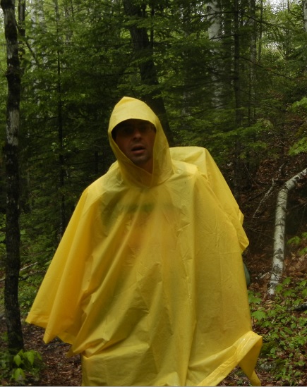
After that, it is a steady downward march with abundance of wet footprints and droppings from wild animals. To make the story more interesting, the rain starts at 12:20. That causes me to put on a bright yellow poncho and leave the walking stick behind – it is cumbersome to walk in poncho and hold walking stick at the same time. And all rain is not a big deal, if you are properly equipped to face it.
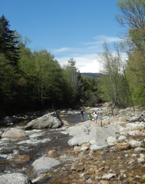
At 12:55, the whole trip took a great exciting turn for the better. Rain has stopped, and sun started to try to play a role. Almost immediately, I have emerged from the woods into the riverbanks. All at the same time, I have met a colorful group of people just fresh from Wild River Campground (2.5 miles away), who were debating whether to go up to complete a loop through Black Angel to Basin trail, and back to their campground.
A well-deserved lunch took place from 1 to 2PM. I crossed the river first without my things in a trail run, and after that I returned to camp on the stones. I started to dry up my things on the sun. Perfect!
Can I add something from the Notebook notes?
[This portion is adopted from notes taken in the tent at 21:00 – 21:29 on 05-24 SAT with the headlight]
I woke up at 05:37. I started the hike at 07:34. At 11:04 I started to walk on Black Angel Trail. First, I had to climb to 2350′, and only then, I could go down. At Wild River (former Spider Bridge site), I ate orange and nuts. Crossing the river here requires agility and caution. Ideally, you should have 2 sticks in your hands for stability. After lunch the weight of the backpack was considerably less noticeable. Last year I already reached this exact place on Monday morning (when was it – most likely May of 2013) right from Wild River Campground. I remember I was almost running back then from 07:50 to 09:06 am.
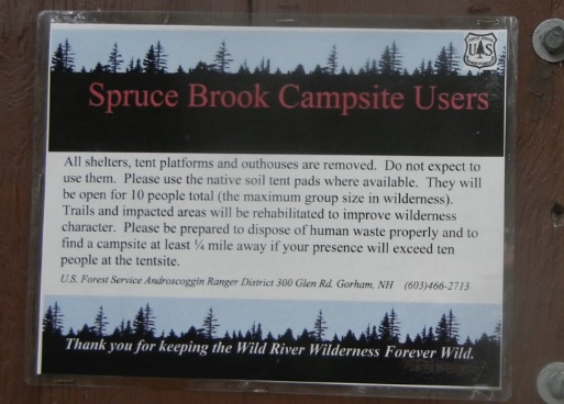
This time the plan was to climb all the way to the source of the Wild River. Around 16:00 I was crossing one more tributary of the Wild River (most likely (Spruce Brook near Spruce Brook tent site) and slipped and the sheer weight of the backpack forced my face right in to the water, but the rest of the body remained above the water, and all the important valet and iPhone remained dry. Good sign!
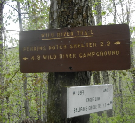
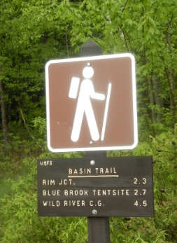
Only around 17:00, I have reached Eagle link. It is interesting, but topo map showed it in a completely wrong spot. I have noticed a marker showing that 2.2 miles remains to Perkins Notch Shelter. First, there is no more shelter there. Secondly, where is the sign to all-important for me East Branch Trail that would be my return way for tomorrow?
As I moved along on a very uncertain, poorly marked and boggy trail, I stopped removing my shoes for river crossings. It seemed that it was just one messy dirty washboard of a terrain.
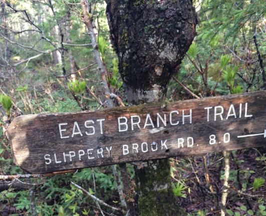
Finally, at 18:06 I have reached the pointer to East Branch Trail! Yes. Tomorrow I would not have to guess, where to start my voyage. It is only 8 miles to Slippery Brook Road from here, and this would be my my direction for tomorrow.
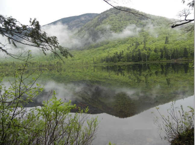
Today I still need to get to Ketchum Pond, where some convenient tent sites laid out. After 2 more “express” river crossings, by 18:30 I was at the Ketchum Pond. This gave me 1hour and 39 min before the sunset. Almost perfect!
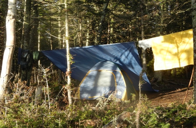
Both tent and tarp were easy to erect, but fire turned out to be a more difficult task. Flame seemed to start OK, but would not grow and would not stay because everything was so wet. Never mind! I just climb into the tent, and started to eat my cold provisions – fried potatoes and soy sausages that Lira prepared back in Boston. It is simply perfect. Plus, a croissant from Price Chopper, and bagel from Connecticut. I even had time to measure 30 minutes to disinfect the water from the spring with special Potable Aqua tablets. After 30 minutes, I have added ascorbic acid tablets to eliminate the iodine taste and even added herbal tea bag for better taste. Right into cold water.
To eliminate any possible food smells from the tent I wrapped remains of my food into several plastic bags, stick them into an unused and not needed pan and hanged it on the tree using the whole in the handle.
Everything else is right here with me in the tent. The extra change battery for the iPhone worked simply great. My iPhone charge percentage fell all the way to 6%. I have plugged in the extra battery to give iPhone some juice. Charge on the iPhone grew from 6% back to 80% while I kept tracking my movements in the wild. In addition, I still had more charge left for tomorrow. Boy! This is exactly what I needed.
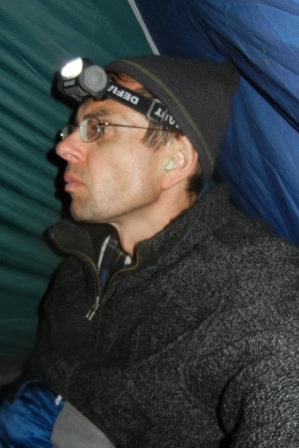
The light, to make these notes possible, is coming from the halogen headlight that runs very reliably on 3 AAA batteries. All these miles I was carrying the metal pan with me. Without fire, it is not needed. Should I leave it here for the next camper? This is the only thing that would not be used, but everything else was very useful on this hike. Sleeping bag, super warm coat, scarf, gloves, and wool socks. I brought with me a complete set of clothes to sleep in. That was a smart idea. Now I can relax in a dry comfortable clean clothes.
For tomorrow, the plan is to get out of the forest first, and then ride back to the car. In case I would fall behind my schedule (I would need at least 6 hours to ride 28 miles to the car) I can always stay at the hotel, and continue my trip on Monday (Memorial day).
It seems early to go to bed right now, but muscles on the back are a bit sore from the backpack.
This is it. I will try to fall asleep right now (21:29).
Navigate through the List
- 01 Crossing Wild River Wilderness - Planning and preparations (2026/02/01)
- 02 First Day – Friday, May 23, 2014 – Hide the bike and walk away (2026/02/02)
- 03 Second day – 2014-05-24 SAT - Into the wild with a plan (2026/02/03)
- 04 Third day – 2014-05-25 SUN – Back to the car and comfort (I) (2026/02/05)
- 05 Third day – 2014-05-25 SUN – Back to the car and comfort (II) (2026/02/06)

Be the first to comment