
Summary: hike 16 AT miles from Wilbur Clearing Shelter over Mount Greylock, through Cheshire, MA to Crystal Mountain Campsite.
05:05 wake up on very dark smoke-filled day. During the night I would wake up three times at 23:45, 01:32 and 04:06. I thought to begin the day at 4am, but it was too dark. Later, I learned that darkness is from a smoke carried hundreds of miles from forest fires in Canada. Finally, I woke up from a strong wind high in the tree canopy, and I thought it was raining. But no. Just a strong wind up in the trees. I still can smell the fire, and I am thinking it is from the firepit at the shelter. No. It is from Canada. Despite the 05:30 sunrise it is still somber and I need to use a flashlight. And it is still very warm in the forest even at elevation 2197′.
05:39 – The first hiker is already leaving the camp. It is still so dark that he needs to use a headlamp. I temporarily repaired the water-bladder hook with duct tape.
06:06 – I start hiking in minimal clothing because it is so warm, with bug spray covering my skin. The morning is dark and gloomy, with a faint smell of smoke that will gradually fade throughout the day.
06:15 Using Money Brook trail, I am back at Appalachian Trail (AT). Now, it is 3.3 mi to the top of Mount Greylock – the highest point in MA. Sign indicates that it is only 2.1 mi back to the car (Pattison Rd.) All that sweating yesterday and only 2.1 mi covered so far.
06:22 Crossing Notch Rd. for the first time. This road goes from North Adams to the top of Mount Greylock.
06:57 elev. 2953 – I am on top of Mount Williams. There is no view down, sky opening but dark clouds and smoke depriving the day of its light.
07:10 trail crossing with Bernard Farm Trail. 2.1 mi remains to the top.
08:02 There are several trails venture up and down at this junction. Bellows Pipe Tr. and Thunder Bolt Ski Tr. are going sharply down to the valley (route 8) and one trail goes up back to Notch Rd. and Robinson Point Tr. Now an open section of a trail starts where you can see that you need to climb up on a steep grassy trail. They must use a mowing machine to keep the trail free from tall grass.
08:18 crossing the autoroute one more time and a last dash to the top.
08:23 Thunderbolt shelter is more a showpiece rather than a shelter. The benches here are polished to absolute shine, and only emergency camping is allowed. There is even a picturesque stone-clad stove for stranded skiers.
08:30 there is a 3D iron map of the local mountain range but camera having trouble picking the minute details on a somber day like today.
08:32 hiked 3.89 today in 2h 30 min (1.6 mph), elev. 3,491′. Bascom Lodge is a hostel for tourists who can drive here and for AT through hikers at the top of the mountain. I eat Lara bar and explore the area around as they open the building only at 9AM.
08:40 I found a faucet with potable water, toilet with toilet paper – what a comfortable place to take a break.
08:56 I start writing my notes outside, but it is a bit chilly and windy, so I want to go inside to hide from cold and wind. The wind creates a very anxious atmosphere.
09:30 I am inside the Bascom Lodge. Unremarkable. There is no one here. There are entrance hall and a large dining area. I sit down in a large room full of tables and chairs by the row of windows. I noticed that load persistent noise suddenly stopped. They were pumping fresh water into the system from a cistern. I do my Duolingo. It is a bit warmer inside, but the cell signal is too weak to connect. I need to go out again.
09:48 I continue the hike. It will be mostly down for a while. My next goal is Mark Noepel Sheter in 3.1 mi. My goal for today is Crystal Mtn Camp. It is 12.4 mi away. There are multiple trails and roads and ladders going in multiple directions up and down the trail.
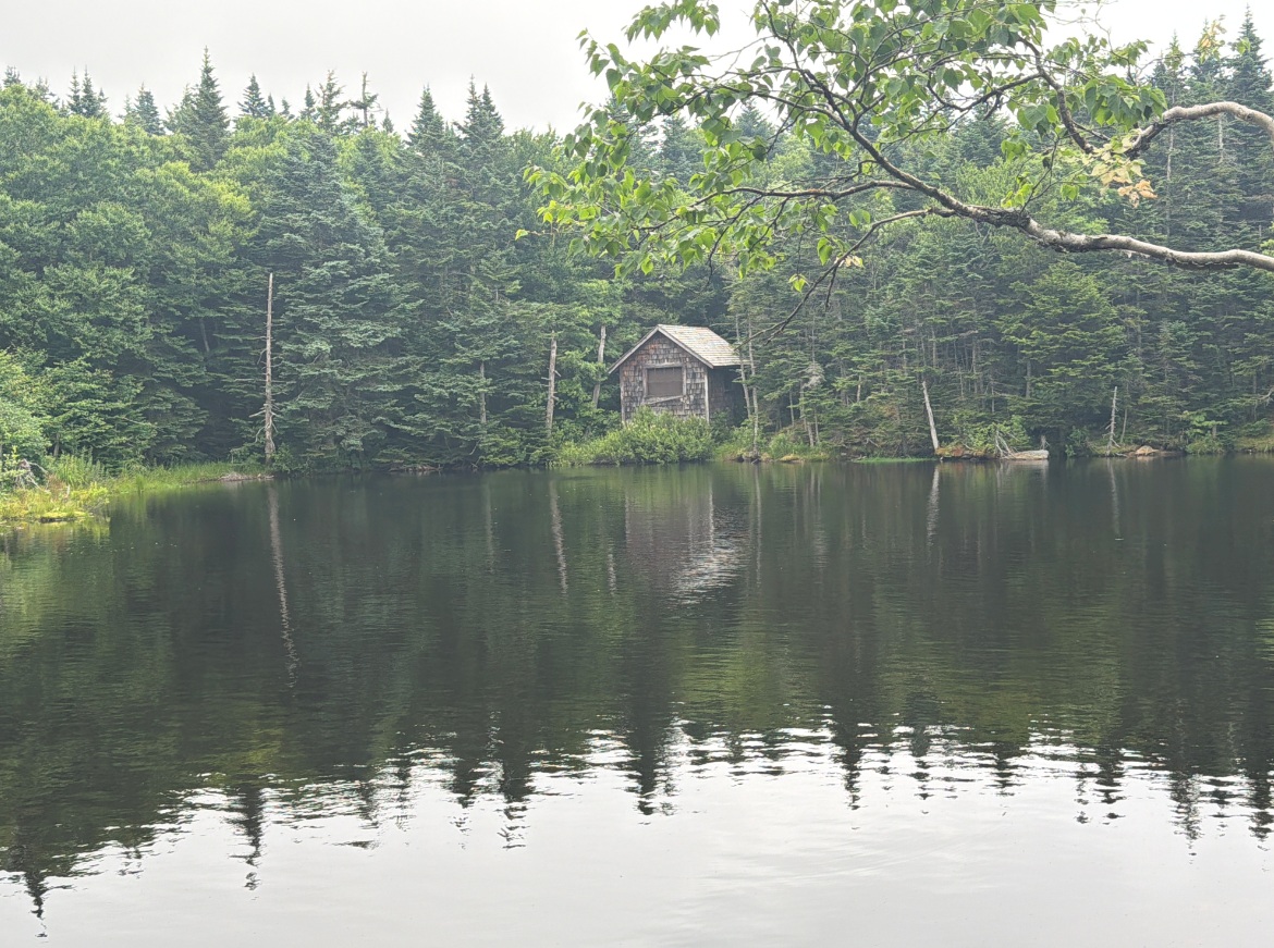 10:14 a picturesque unnamed pond with an abandoned cabin right on the shore. It is like a theme from a ferry tail.
11:26 crossing a junction with Jone’s Nose Trail. From here the trail begins to go sharply down from 3200′ and all the way down to valley to 1000′.
11:45 – 12:24 hiked 7.27 mi/ 9.5 more to go. Elev. 2670′. I am at a side trail to Mark Noepel Shelter. Here at the shelter I met a daughter and grandmother that I saw yesterday at 4:30 PM at my starting point in North Adams. What an interesting coincidence. Yesterday, they were finishing their hike for the day and I was just starting. I climbed on a second level bank and wrote my notes with my back resting against a supporting beam. Someone left a sleeping pad here, so I used it for cushioning. There is a semi-permanent feature here – a hiker on unemployment (or some other state benefit) with a cell phone issued by state who smokes marihuana, listens to country music, and enjoys life more than any of us – mortals.
12:24 Continue the hike. The town of Cheshire, MA is 5 mi away and I would need to go down to 1000′ and then back up again to over 2000′.
12:47 AT crosses Old Adams Rd. This road is a wide trail, used by snowmobiles.
13:28 an interesting trail section where you can see how sharply the slope goes down because tall trees do not obstruct the view and there is no underbrush.
13:48 – trail is crossing under a power line. We are approaching civilization.
13:57 – crossing a well paved Outlook Ave. There is sign here to climb stand-alone Raynold’s Rock – an interesting landmark.
14:04 – elev. 1291 – I passed open meadows from where I can see wide views back and forward. This section reminds me of meadows in Vermont along AT. There is a bench here in shade between two fields. The fields here left to recover and only a narrow pass mowed for the hikers in the wild grass.
14:23 – I am crossing route 8. We used to drive here every day on the way to work in 1992-93. And I never knew about Appalachian Trail while we lived in Adams, MA. Next section will go on the city streets on Cheshire. I like the variety. The helpful sign says that it is only 4.6 mi left to the camp for today.
Green corridor in the city-limits with a sign – ‘No Hunting!’ and ‘Trump was Right about Everything’. Post Office has an easy to remember zip code 01225. I am sending Lira a notification that I am in Cheshire, and she is surprised that trail goes right through the city streets. Also, here I am crossing a new bike trail with a memorable long name – Ashuwillticook Rail Trail – that I would need to take on Friday on the way back to the car.
14:55 -15:08 – hiked 12.5 mi/ 4 mi remaining, elev. 1051′. My speed hiking down Mount Greylock was 2.2 mph. The city portion of trail through Cheshire is behind me. I am re-entering into the “green corridor”. At this point I am tired and 4 mi is a formidable task ahead of me.
15:44 I am passing Cheshire Cobble viewpoint. I do not know what that is and I do not care. I just want to go forward and make progress.
15:53 – a rare clearing at the trail – I can see distant body of water below – Cheshire Reservoir. It is a view towards invisible from here route 8.
15:54 – 17:53 Strangely, there are no pictures taken for the next 2H between. I am too focused on finishing the hike.
16:02 – 16:06 – hiked 1.4 mi / 2.6 mi remains, elev. 1778′ – I already climbed back up to the ridge. There is a bit more to climb for me to 2200′ and then down to the shelter. No thoughts, no emotions, just an inner drive to go forward.
17:03 – 17:07 – the speed is my moto right now. Only 0.9 mi remains. I already hiked today a distance of 15.5 mi. And 24.4 mi remains until the destination in two nights.
~17:15 I am at a Gore Pond Outlet – elev. 2021′. I can see a miserable pond at a distance. The water is too warm and too murky as it flows out of the pond. But I am collecting the water anyway just in case there is none at the shelter.
17:43 – 17:51 the shelter is near and the brook is here. I will dump the water that I was carrying for half a mile and collect new cold, clear water. I am so close to the target.
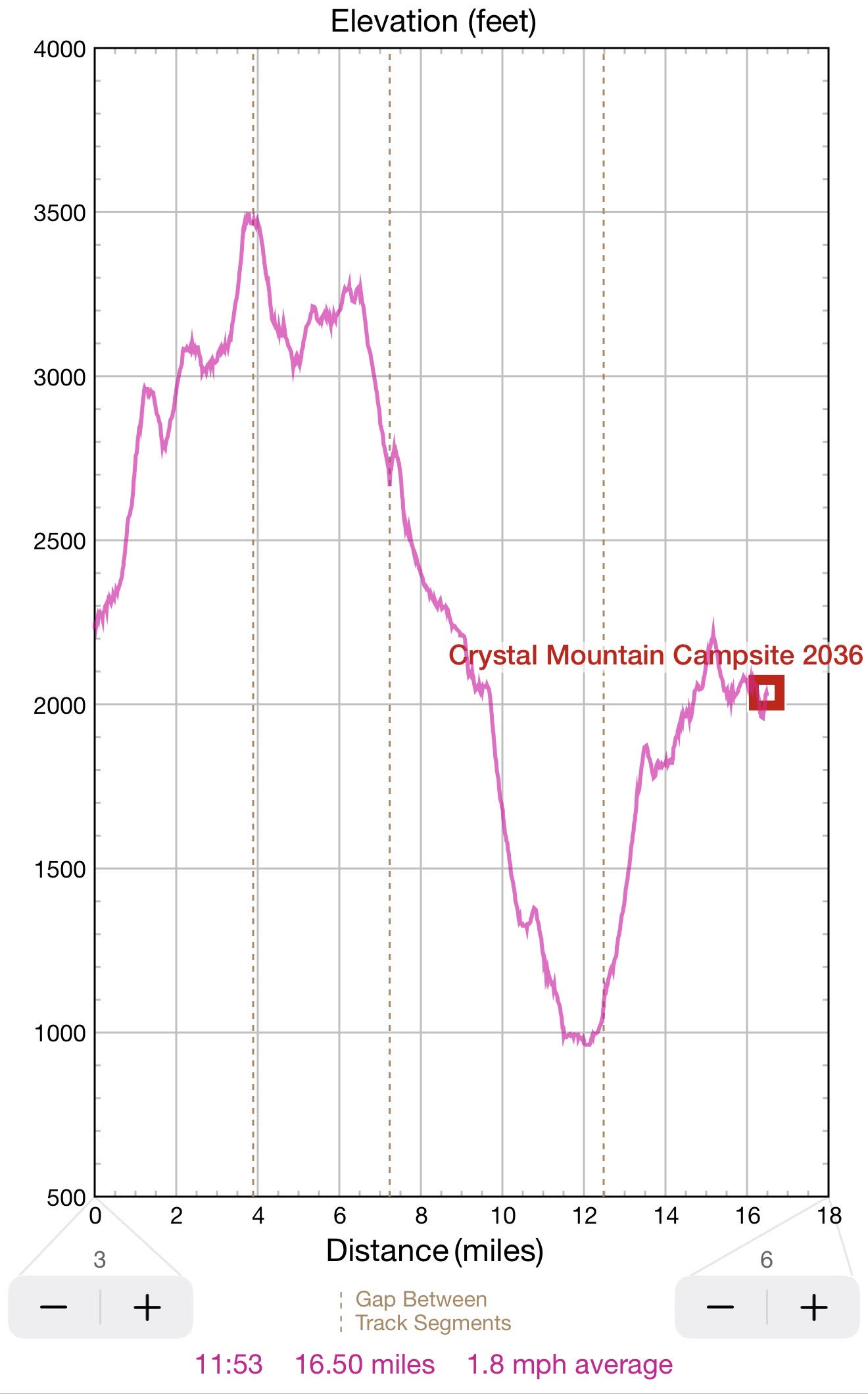
17:53 – Finally, I reached the Crystal Mountain Campsite after 12H of hiking. Today’s total – 16.5 mi. Total distance from the start – 18.2 mi. Total miles remaining to Mass Pike – 23.6 mi.
18:00 – Here at the campsite they have a table, a bear box, 5 to 7 spaces for tents and there are no platforms. It is +22°C and it will remain warm and dry till Saturday. With a weak signal I just learned that England lost 1:2 to Argentina, and now in the grand finale Spain will play Argentina on Sunday 7/19.
18:12 While I am alone here and there is no competition, I need to pick the best site for a hammock. I am picking the most remote site at the end of a corridor about 60 to 80 yard away from the table, the fire ring and the entrance to the camp.
19:14 hammock is hanging. I left all the kitchen cooking and food stuff at the table and brought everything else to near my sleeping quarters. The vegan meal for today will be Good to Go Mushroom Risotto. The second helping of water is on the stove. I am drinking hot strong tea with one packet of sugar. I on a 10th minute of waiting (out of 20) for the meal to hydrate and be ready to eat. I am adding a bit of olive oil, Grape Nuts, and a mix of various nuts to the meal. Mosquitoes are sparse and lazy. And I am still alone at the camp – Could it be real?
19:28 The evening colors are getting just a bit more somber. If I have energy, I will bring a flashlight later. The third helping of water is on the stove. I am adding more salt and “crushed” nuts (crushed by my jaws) into the meal.
19:37 Although picnic table is a major improvement compared to cooking and eating on the ground, sitting at the table is not extremely comfortable as my back is not resting against any support. While waiting, I am adding into my risotto much more water that prescribed as I want to reach a soup consistency.
19:57 Ok. I am finishing with the kitchen. I pack everything in one big bag and place it into a bear box for the night.
20:34 I attach my 3-liter bladder using knot on a tree. Now I can wash my face and hands. I am finishing the tea, hanging everything to dry out including the paper cups. There is no rain tonight according to forecast. Mosquitos present and couple even sneaked into the hammock. Not to worry. One by one I am eliminating them with flashlight and my fists. I am still alone at the camp, but I can hear regular cannon-like sounds from a distance as if a truck dumps the load or someone forcefully slams the giant door.
Milestone today:
5AM - wake up in smoke filled forest,
6AM - start the hike,
8:30 AM - arrive at Mount Greylock,
10AM - start the hike down from Greylock,
12PM - arrive at the next shelter,
2PM - emerge from the forest and hike in the meadows down and down to the valley,
3PM - cross Cheshire, MA and prepare for the last 4 mi dash to the camp, most difficult miles,
4PM - 2.6 mi remains.
5PM - 0.9 mi remains.
6PM - arrive at Crystal Mtn Camp with a bladder of crystal-clear water.
20:48 with a weak signal I can do my Duolingo right in the hammock – a rare benefit.
21:17 That is it. The whole trip is going well. It started just yesterday, but it already feels like I am in proper outdoor rhythm. Now I am tired and ready to go to sleep. The weather tomorrow will be sunny and comfortable – 15-24°C.
Navigate through the List
- 01 2026-07 Re-route work and appointments to free up time for 5th trip (2026/07/13)
- 02 2026-07-14 TU sudden start of the trip to Western MA (2026/07/14)
- 03 2026-07-15 WE - southbound over Mount Greylock to Cheshire and beyond (2026/07/15)
- 04 2026-07-16 TH - almost flat map section around Dalton, MA (2026/07/16)
- 05 2026-07-17 FR - finish one of the last AT sections in CT, MA, VT, NH and ME (2026/07/17)
- 06 2026-07 Fifth AT trip in two months (2026/07/18)
Be the first to comment