Tagged: Wally Plastic оптом со склада
- This topic has 0 replies, 1 voice, and was last updated 5 years, 10 months ago by
Udar Gromov.
-
AuthorPosts
-
2020-08-19 at 14:50 #7917
Udar Gromov
KeymasterSummary: hike last 1.8 mile to a parking lot, drop the backpack and then hike one more mile to Maine Junction where Long trail finally depart from Appalachian Trail.
Return to parking area and bike 32 miles back to car.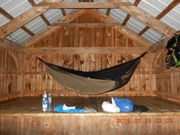 02:02 The night was warm, and mosquitoes did not stop with the darkness. I could not sleep with their busing even with mosquito net and ear plugs. So, I woke up and spread the hammock from wall to wall. While doing this, I also discovered some ant activity that I tried to stop with bug spray. I also tried to take pictures of the stars- it was an exceptionally dark night, but the picture turned out to be completely black. But the night picture of the hammock shows that I did a good job hanging my bed and lining all my thing along the edge of the shelter on the floor. Nice, convenient, and I finally was able to concentrate on sleeping. What also helped, that I was alone in the shelter.
06:06 – wake up in the hammock. Today is a very long return home day. I will da short hike and a long bike ride to get back to the car.Hiking Sector 1 07:22 – 08:32 = 1:10 2.06 mi (1.8 mph) down to VT route 4
08:28 – footbridge just before route 4. Now I will drop the backpack in the woods and will go 1 mi to Maine junction where At and LT depart.Hiking Sector 2 08:34 – 09:03 = 0:29 1.00 mi (2.0 mph) – a quick walk to AT/LT junction without backpack
08:35 – I am crossing the road and entering last section where AT and LT are together. There are very many different sign and notes upon entering this section of the trail. One of pictures taken shows an old and new relocated AT/LT. Old section of the trail remains available and now is called Sherburne Pass Trail. I did not know this while I was there on location.
09:03 – I am at Maine junction – a place where AT and LT are splitting after 90 some miles together. In May and two July trips I did all these miles except for 1.9 mi between National Forest 71 Rd. and Arlington-Stratton Rd. Here I have met Stephanie – an LT hiker, whom I saw 2 days ago at Minerva Hinchey Shelter. She was much faster than me, and quickly disappeared up the trail. Now, she was returning from a popular resting place to resume her journey northward.Hiking Sector 3 09:08 – 09:52 = 0:44 1.21 mi (2.1 mph) – walk back to the bike
09:40 – there still some posters remain from May 6 closure order for all shelters and privies due to COVID-19. As of June 26, everything is reopened, but confusing posters remained.
10:12 – I am ready to bike back to the car. Bike is recovered and loaded with heavy backpack. Wooden walking stick will stay behind. Immediate plans are to avoid direct sun exposure while riding a bike, to avoid traffic while returning to Boston. And craving for a toasted Subway black forest sandwich is also very close to the surface.
10:22 – start the bike ride. Sun is out. It is just getting hot now. Apply sunscreen.Biking sector 4 10:21 – 10:52 = 0:31 7.21 mi (14.0 mph) – sharp down towards Rutland (Subway)
10:54 – 7.2 miles completed – 24 to go I am at a parking near Subway in Rutland (217 Woodstock Ave Suite A, Rutland, VT 05701). It is tempting to go in, but I have my apple and an orange, and I do not want to break my lucky $36 dollars (20 + 10 + 5 + 1) from a bundle. I drink coconut water instead iPhone charge – 81%.Biking sector 5 11:02 – 12:01 = 0:59 9.34 mi (9.7 mph) – mostly flat through Rutland along the river
11:51 – asphalt is over. It is a nice gravel road. The road goes parallel to a nice quiet river. About half the distance is complete.
12:05 – 16.5 mi complete – 15 mile remains. I was riding for a long time along Creek Rd. in North Clarendon that is parallel to route 7, but quiet and not dusty. Nice. I found a river public access point. It is just an imaginary narrow path in the grass, but it is there. And there is a tree where to lean my bike heavy against. Looking at the map now, I see that I picked a spot where Otter Creek and Mill River are just merging onto one. River banks here are very muddy, but I found 3 Home Depot buckets that someone left behind most likely for fishing purposes and I arranged my stuff around these imaginary chair and tables so that I can rest, think and even write.
12:16 – message to Lira – I am 15 miles away from the car. Sun is hiding somewhere, but sky is blue. That is nice as I am preparing to enter a torturous, busy, and hot route 7 section.
12:52 – refreshed after the swim in the creek. The river bottom is wonderful and sandy. Current is mild and the depth is just enough to be comfortably covered in water in a sitting position like in a bath tab. Ii is basically a freshwater spa for one. Very nice!Biking sector 6 12:52 – 13:51 = 0:59 7.31 mi (7.8 mph) – slightly up on busy VT route 7.
13:17 – entering route 7 near Wallingford post office.
13:53 – 23.9 completed – 7.9 remains. I am in South Wallingford next to Marble query. A rest by the road. Bike is leaned against a knee-high stone wall. Cars are whizzing back and forth. According to my calculations, there are 4.9 mi remains on a highway and then 3 mi on a local Brooklyn Rd. up and up to the AT parking lot.
The shoulder is narrow, and I decided to turn on red blinking light for safety. Despite heavy backpack, the backlight is not blocked and clearly visible to passing cars. iPhone charge 61%.Biking sector 7 14:07 – 14:42 = 0:35 4.47 mi (7.6 mph) – mostly flat to Mt. Tabor township
14:47 – I gave it all my energy, and I had to stop by railing just to get energy back. I am tired but feel good. The aim is near, but I can’t relax yet. Completed 28.4 mi and 3.5 mi remains. Highway will be over in 0.4 mi. Temperature is 31°C, but I do not feel that heat. My location is very close to Mt. Tabor and Danby border. iHikeGPS APP is full, and I need to clear some space. I diligently create screen prints and email GRP track for that day to clear the space. I wonder why iHikeGPS has such a low capacity for recording. It always runs out of space on the fourth day of hiking and biking.Biking/walking sector 8 14:56 – 16:02 = 1:06 3.62 mi (3.3 mph) – sharply up on the Brooklyn Rd toward AT/LT parking lot.
Before hiding the bike, I knocked on same spacious house door, but no one has answered. So, I moved on.
15:12 – I hide the bike on someone’s forgotten driveway and started to walk remaining 2 miles up the road without any load. I did not take any water, or food. Just camera, iPhone, and car keys – important. The plan is to walk the steepest section of the road and then return to the bike down the hill.
I have tried to stop 5 or six cars, but apparently Sunday afternoon is not a good time for hitchhiking. No one stopped.
15:49 – Big Branch Overlook reached. I am so close now.
16:02 – reached the car – everything is great. Last time I was returning 3 week ago (on July 5th) to the same parking lot but from above.Bike Summary: 5:41 – 31.96 mi – 7.8 mph
In an absence on pen, the following is written in Russian in iPhone notes at 16:50 on Sunday 07-26 at the very end of the trip:
Написано на берегу реки Big Black Branch 2020-07-26 Sun 16:50.
Стучался в один дом – не ответили. Оставил вело просто в каком лесочке на чьем-то driveway. Прошел 2.3 mi. Проехало 5 машин – ни одна не остановилась.
16:02 – дошёл до машины.
16:09 – спустился вниз и стал отвязывать рюкзак.
16:19 – поехал обратно к реке под мост.
16:26 первая фото уже здесь – на пляже.
Нашёл укромное местечко, где купаться голеньким – за огромным камнем – класс! Искупался и обнаружил что забыл взять сюда ручку – поэтому пишу на iPhone. До дома – 3 часа 6 мин.
16:50 swim at Big Branch river – nice spot under the sun
Uneventful drive back home to Boston.
20:06 – odometer 355.1 – +30°C – arrive home just in time for dinner. -
AuthorPosts
- You must be logged in to reply to this topic.