- This topic is empty.
-
AuthorPosts
-
2020-08-31 at 14:21 #7963
Udar Gromov
KeymasterSummary: as day progressed, the weather forecast was worsening for tomorrow. I would need a shelter tonight. But I have reached the planed Wintturi Shelter too early to stop – a 14:40. It was 10 miles to the next shelter, and nothing prominent except a Lookout marked on the map as private. It turns out to be a hut or a house with widow walk on the roof for a view and no water. I found water and stayed here with several other hikers.
06:10 – I woke up and started to climb out of my cocoon. Not a single nature call during the night, although I was awake many, many times. Hammock toughed the ground just a bit, so it was a good combination of softness and zero swinging. Good. Tarp wrapped around sleeping bag really helped
06:33 – sun just jumped out from the other side of the hills, and now I can try to dry out all the morning dew that condensed during the night. There is this certain stillness in the morning when for a short moment there is nothing to do – just be. Location of this camp is excellent – views in the evening and sun in the morning.
 07:00 I am sitting in the hammock and freed myself from gliding down problem for a moment. I am dressed in a hoodie, but sky is clear it will warm up very quickly. First water bottle is empty – good – lighter load to carry.
08:04 Completed breakfast with a mix of cold water, cereals, dry fruits, and trail mix. Wonderful! I think I will be ready to hike in 20 min.
Hiking sector 1 – 08:36 – 10:33 = 1:57 3.12 mi (1.8 mph) – up and down to Woodstock Stage Rd and then steady up to Dana Hill
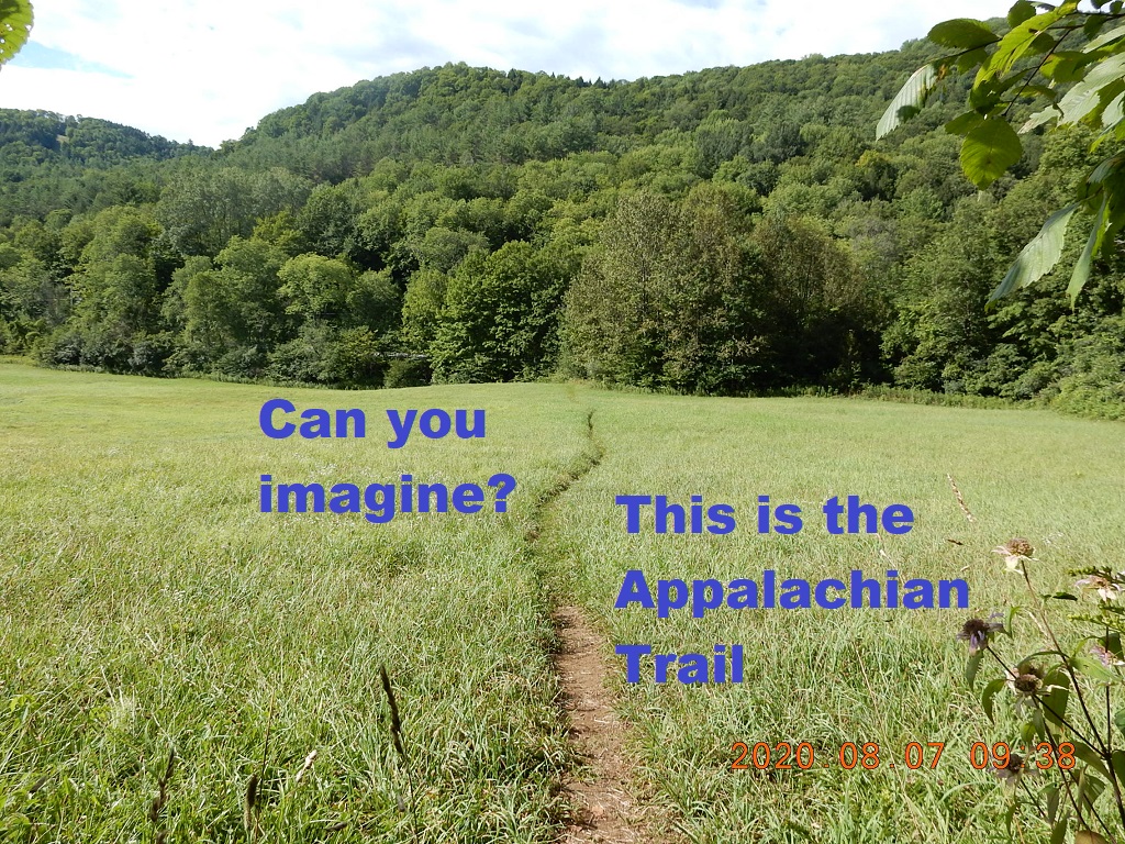
This is a very green section with a very narrow path among high grasses. Morning dew leaves wet impression on you pants. But it is fun because every moment a new something is appearing behind the bend.
09:41 – crossing Woodstock Stage Rd. Th sign show 6 more miles to my today’s goal – Wintturi Shelter. After crossing the road, the forest is light and bright.
10:45 I at Dana Hill – 1,528. I will spend here almost an hour. Notify Lira about my whereabouts. Reached a milestone 250 days in a row with Dualigo. My eyes are on the weather – will it rain, how much and for how long. It feels that Wintturi Shelter is just too close to stop for tonight. And how will I go under the rain tomorrow?
 Hiking sector 2 – 11:28 – 12:37 = 1:09 2.16 mi (1.9 mph) – down to VT route 12 and to an unnamed hill to sit under a tree
11:57 – crossing VT route 12. This is a big important road with a good size parking.
After crossing route 12 and a river over footbridge, you are entering meadows one last time. Here they have 2-3 steps dual wooden ladders to cross the field fences, but in most cases wired fence is damaged and people go around the ladder into next field.
I found a wooden stick and I was asking passersby if they have a saw. Finally, I found a good clearing on top of the next hill and started to cut the stick with a small folding knife. Nice. It worked. And now I would have 2 sticks. One is Cascade Mountain Tech carbon fiber miracle trekking pole and another just a cut to order wooden stick.
Hiking sector 3 – 13:18 – 14:49 = 1:30 2.62 mi (1.8 mph) – from unnamed hill up and up to Winttiri Shelter with a new wooden stick
13:09 5.3 mi complete, about 3 mi left till shelter. Chance of rain 40% all night tonight.
14:37- I arrived at the Wintturi Shelter side trail. Please note that this spelling with double “T” is on Google Maps and on one trail sign. Alternative spelling with double “R” is on National Geographic AT map.
Hiking sector 4 – 14:50 – 16:12 = 1:22 2.46 mi (2.0 mph) – from Wintturi Shelter to Lookout Farm via Pinnacle (2,510).
15:45 – sign to Green Gate Rd. where all day hikers are coming from.
16:04 – sign to a Lookout – 0.1. OK. I will take a bite.
16:36 – pictures at the private lookout hut. This is a good size one-room hut with an attic and a widow walk on the roof. Perfect place in all respects except there is no water nearby.
Hiking sector 5 – 16:46 – 17:17 = 0:31 0.79 mi (1.6 mph) – 0.4 reconnaissance trip down unnamed road in search of water
A couple who were already here (Captain Haddock and his wife) told me that there is no water for at least 2.5 mi south bound. [Tomorrow I will encounter the first water only 2 hours after leaving the lookout hut.] And coming from the north, I did not see any water either. So, what to do? Lakota Lake is visible from the roof of the Lookout Farm – another name they use for the property and the hut. May be there is a shortcut? – No. All tiny would have been trails are dead ends. But how did they bring materials to build this hut? There is a tentative forest road that goes sharply down. So, I tried that road and in 0.4 mi I found a tiny spring crossing the road, and I was able to catch the water by using a leaf create a mini waterfall and water scoop collect the falling droplets. The whole water expedition took from 16:46 to 17:16 – exactly 30 minutes. And now, I had 3 liters of water and place to stay away from rain.
Hiking Summary – 08:36 – 17:17 = 8:41 11.27 mi (1.9 mph)
~~18:00 I cooked my food on the entrance steps as there is no table neither inside nor outside the structure. With all the extra AT trip I was able to take this year, I finally used the meal that I was postponing because of low salt content – AlpineAire Foods Santa Fe Black Beans & Rice Vegetable Burrito. To solve this taste problem, I simply added salt to taste instead of skimping. When the meal was ready, I climbed up to widows walk to eat with a view from the top.
19:02 – time for pictures again. On the ground a family of 2 boys and a mother with masks decided to start a fire – so I helped with ideas and firewood.
19:54 – pictures of sun preparing for setting. At this time probably 5 or 6 people were on top of the house for pictures and communication through social distancing. All were in masks because the mother and the boys were wearing the masks.
20:48 – there are 4 hiker downstairs, but here in the attic I am alone with window open. It is dark, so I write with a flashlight. Today I did potentially 1.8 to 2 extra miles from Wintturi Shelter, so tomorrow I potentially can reach Thunder Falls and my bike.
Several hikers decided to camp out in tents probable because of COVID or snoring and fresh air. Whatever the reason, they will be experiencing approaching rain that already visibly taken half of the sky.
-
AuthorPosts
- You must be logged in to reply to this topic.